 DataSuds-geo
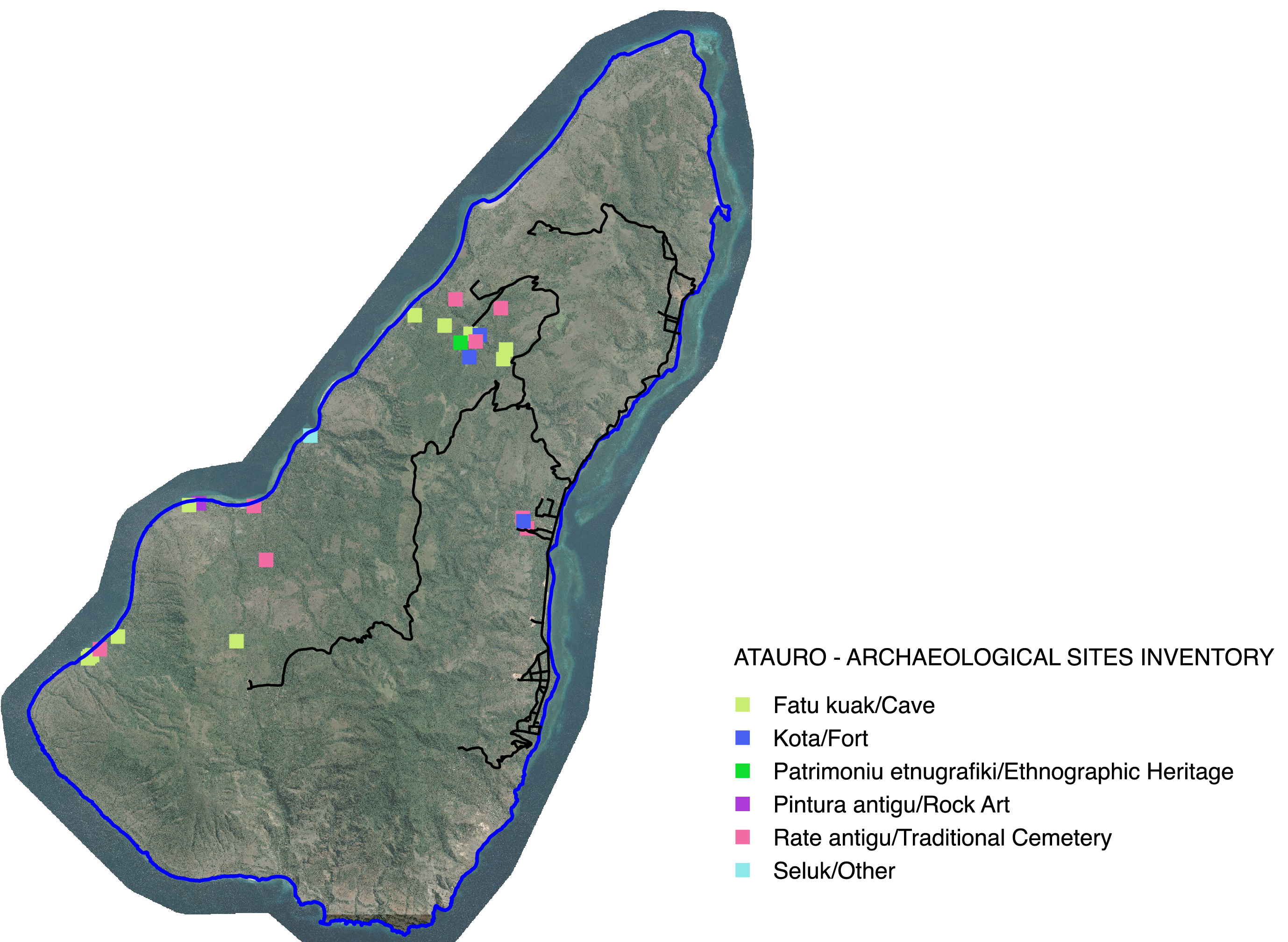
Sites archéologiques - Île d'Atauro - Timor oriental - Asie
Archaeological sites- Atauro Island - East Timor - Asia
Identification et numérisation des sites archéologiques de l'ïle d'Atauro, Timor oriental. Les données collectées sont issues de terrain réalisés sur l'ïle d'Atauro entre 2013 et 2020 par Jean-Christophe Galipaud dans le cadre de missions financées par l'IRD puis par le programme ANR 18-CE27-020.
Identification and digitization of archaeological sites on Atauro Island, East Timor. The data collected comes from fieldwork carried out on the island of Atauro between 2013 and 2020 by Jean-Christophe Galipaud as part of missions funded by the IRD and then by the ANR 18-CE27-020 program.
Simple
-
Date (Publication)Date (Publication)
- 2024-07-24
- Edition
-
IRD
Citation identifier
Identificateur
-
Presentation formForme de la présentation
-
Digital mapCarte numérique
-
ButPurpose
-
L’enjeu de ces données sur le patrimoine est de répondre aux attentes des populations tout en préservant le caractère confidentiel ou de circulation restreinte de certains savoirs ou histoires. Des cartes, établies à la demande, sont le support de restitution locale privilégié dans la mesure où toute la chaîne opérationnelle, du point GPS à l’information qui y est associée et à son traitement graphique, est visible et accessible aux techniciens du SEAC formés par le projet et à une partie dela population locale.
The challenge of this heritage data is to meet the expectations of local people while preserving the confidential nature or restricted circulation of certain knowledge or stories. Maps, drawn up on request, are the preferred medium for local dissemination insofar as the entire operational chain, from the GPS point to the associated information and its graphic processing, is visible and accessible to the SEAC technicians trained by the project and to part of the local population.
-
StatusEtat
-
CompletedFinalisé
- Point of contact
-
Organisation name Individual name Electronic mail address Role UMR PALOC - IRD, MNHN, CNRS - France
Institut de recherche pour le développement
Jean-Christophe Galipaud
Dominique Guillaud
Resource providerFournisseurUMR PALOC - IRD, MNHN, CNRS - France
IRD-UMR PALOC
Elisabeth Habert
Elisabeth Habert
AuthorAuteurUMR PALOC - IRD, MNHN, CNRS - France
IRD - UMR PALOC
Elisabeth Habert
Elisabeth Habert
Point of contactPoint de contact
-
Maintenance and update frequencyFréquence de mise à jour
-
Not plannedNon planifiée
- Metadata author
-
Organisation name Individual name Electronic mail address Role UMR PALOC - IRD, MNHN, CNRS - France
IRD - UMR Paloc
Direction UMR Paloc
Dominique Guillaud
Resource providerFournisseurUMR PALOC - IRD, MNHN, CNRS - France
IRD
Elisabeth Habert
Elisabeth Habert
Point of contactPoint de contact
-
ThemeThème
-
-
Patrimoine, archéologie
Heritage, archaeology
-
-
PlaceLocalisation
-
-
Timor oriental, Atauro
Timor oriental, Atauro
-
-
Access constraintsContraintes d'accès
-
Intellectual property rightsDroit de propriété intellectuelle / Droit patrimonial
-
Use constraintsContraintes d'utilisation
-
CopyrightDroit d’auteur / Droit moral (copyright)
-
Autres contraintesOther constraints
-
Utilisation libre sous réserve de mentionner la source en citant l'origine de la donnée quand elle est utilisée pour une publication : Programme ANR 18-CE27-020 - UMR PALOC - J-C. Galipaud, E. Habert -
Free use subject to mentioning the source and citing the origin of the data when used for publication: Programme ANR 18-CE27-020 - UMR PALOC - J-C. Galipaud, E. Habert -
-
Spatial representation typeType de représentation spatiale
-
VectorVecteur
-
DenominatorDénominateur de l'échelle
- 100000
-
LanguageLangue de la ressource
- Français
-
Character setEncodage des caractères
-
UTF8Utf8
-
Topic categoryCatégorie ISO
-
-
SocietySociété
-
- Begin date
- 2013-05-19
- End date
- 2020-10-28
))
-
Reference system identifierNom du système de référence
- WGS 1984 - EPSG 4326WGS 1984 - EPSG 4326
-
Geometric object typeType de géométries des objets
-
PointPoint
-
Geometric object countNombre d'objets géométriques
- 26
- Distribution format
-
Name Version Vecteur ou Shapefile,etc
Vecteur ou Shapefile,etc
Distributor
Distributeur
- Distributor contact
-
Organisation name Individual name Electronic mail address Role DataSuds-geo
IRD
PublisherEditeur (publication)
- Distributor format
-
Name Version Vecteur ou Shapefile
Vecteur ou Shapefile
- OnLine resource
-
Protocol Linkage Name OGC:WMS https://datasuds-geo.ird.fr/geoserver/paloc_ws/wms SItes_Archeologiques_Atauro
OGC:WFS https://datasuds-geo.ird.fr/geoserver/paloc_ws/wfs paloc_ws:SItes_Archeologiques_Atauro
DOI https://doi.org/10.1080/03122417.2021.1889085 Timorese archaeobotany: An anthracological pilot study at the late Holocene Lepu-Kina rockshelter, Atauro Island, East Timor
Timorese archaeobotany: An anthracological pilot study at the late Holocene Lepu-Kina rockshelter, Atauro Island, East Timor
DOI https://doi.org/10.4000/12xv1 Conflits, sites défensifs et tradition orale : histoire du peuplement d’Atauro
Conflict, Defensive Sites and Oral Tradition: A History of Settlement in Atauro
- OnLine resource
-
Protocol Linkage Name DOI
https://doi.org/10.23708/015195a0-ae5b-455e-9ca4-4cab44274fcd Digital Object Identifier (DOI)
-
Hierarchy levelNiveau
-
DatasetJeu de données
-
Généralités sur la provenanceStatement
-
Données GPS récoltées lors de missions de terrain réalisés sur l'ïle d'Atauro (Timor oriental) entre 2013 et 2020 par Jean-Christophe Galipaud, UMR PALOC - IRD/MNHN
GPS data collected during field missions on Atauro Island (East Timor) between 2013 and 2020 by Jean-Christophe Galipaud, UMR PALOC - IRD/MNHN
Metadata
-
File identifierIdentifiant de la fiche
- 015195a0-ae5b-455e-9ca4-4cab44274fcd XML
-
Metadata languageLangue
- Français
-
Character setJeu de caractères
-
UTF8Utf8
-
Hierarchy levelType de ressource
-
DatasetJeu de données
-
Date stampDate des métadonnées
- 2025-03-14T10:10:13.191471Z
- Metadata standard name
-
ISO 19115:2003/19139
- Metadata standard version
-
1.0
- Metadata author
-
Organisation name Individual name Electronic mail address Role IRD
IRD - UMR PALOC
Direction UMR PALOC
Elisabeth Habert
AuthorAuteurIRD - UMR Paloc
IRD - UMR Paloc
Jean-Christophe Galipaud
Dominique Guillaud
PublisherEditeur (publication)
- Other language
-
Language Character encoding EnglishAnglaisUTF8Utf8FrenchFrançaisUTF8Utf8
Overviews
Spatial extent
Provided by
