 DataSuds-geo
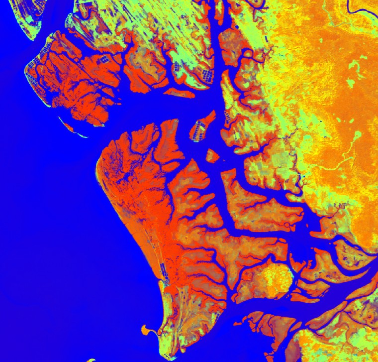
Distribution de la mangrove au Cambodge en 2020
Mangrove distrbution in Cambodia in 2020
Cette carte de la répartition des mangroves au Cambodge en 2020 a été réalisée à partir d'images Sentinel 2 datées de janvier 2020 obtenues à partir du navigateur Copernicus ( https://browser.dataspace.copernicus.eu/). Les images couvrent 4 tuiles Sentinel 2 (T48PTT, T48PUS, T48PUT, T48PVS), situées sur la côte cambodgienne et couvrant les écosystèmes de mangroves du Cambodge. Au total, 4 produits raster sont disponibles, un produit binaire pour chaque tuile, avec des valeurs de 1 correspondant aux mangroves et des valeurs de 0 correspondant aux zones non mangroves. Les cartes des mangroves ont été obtenues selon une méthodologie développée dans le cadre du projet Mangmap ( https://mangmap.org/en/) et disponible ici ( https://mangmap.org/en/produit/le-vecteur-de-contour-des-mangroves/). Pour chaque mosaïque Sentinel 2, un raster multibande a été produit en combinant les indices NDVI, NDWI, SWIR et le MNT Copdem à une résolution de 30 m. Une approche par seuillage a été appliquée à ce raster multibande afin de détecter les pixels correspondant à des mangroves et de produire une carte finale à une résolution de 30 m pour chaque mosaïque.
This map of mangrove distribution in Cambodia in 2020 was produced using Sentinel 2 images dated january 2020 obtained from the Copernicus Browser ( https://browser.dataspace.copernicus.eu/). The images cover 4 Sentinel 2 tiles (T48PTT, T48PUS, T48PUT, T48PVS), located on the coast of Cambodia and covering the mangrove ecosystems of Cambodia. A total of 4 raster products is available, one binary product for each tile, with values of 1 coresponding to mangrove and values of 0 corresponding to non-mangrove. The maps of mangrove were obtained following a methodology developed in the fram eof the Mangmap project ( https://mangmap.org/en/) and availbale here ( https://mangmap.org/en/produit/le-vecteur-de-contour-des-mangroves/). For each Sentinel 2 tile, a multi-band raster was produced combining NDVI, NDWI, SWIR and the Copdem DEM at 30 m resolution. A thresholding approach was performed on this multi-band raster to detect mangrove pixels and to produce a final map at 30 m resolution for each tile.
Simple
-
Date (Creation)Date (Création)
- 2026-02-16
-
Date (Publication)Date (Publication)
- 2026-03-17
Citation identifier
Identificateur
-
Presentation formForme de la présentation
-
Digital mapCarte numérique
-
ButPurpose
-
Cette carte de la répartition des mangroves au Cambodge en 2020 a été réalisée afin de servir de référence pour les actions de recherche qui seront menées dans le cadre du projet ANIMALS et pour les activités de suivi opérationnel qui seront mises en place dans le cadre du projet MangMap. Dans le cadre de ces deux projets, des images satellites à différentes résolutions spatiales (Sentinel 2 et Pléiades) seront utilisées pour produire :
- des connaissances actualisées sur les habitats de mangrove, la biomasse aérienne (AGB) et les stocks de carbone aérien (AGC) grâce à la très haute résolution spatiale fournie par Pleiades (50 cm) ;
- un suivi de l'évolution de la répartition des mangroves à l'aide des séries chronologiques de Sentinel 2 (résolution de 10 m) à partir de 2020, et une contribution au développement d'un système d'alerte dédié à la détection précoce des changements affectant les mangroves au Cambodge.
Ces données sont destinées à être pleinement accessibles aux projets en cours, y compris aux partenaires impliqués et à tout acteur intéressé par la conservation des mangroves au Cambodge.
This map of the distribution of mangrove in Cambodia in 2020 was produced to be used as a reference for research actions that will be developed in the frame of the ANIMALS project and operational monitoring actions to be developed in the frame of the MangMap project. In both these projects, satellite imagery at different spatial resolutions (Sentinel 2 and Pleiades), will be used to produce:
- up to date knowlegde on mangrove habitats, above-ground biomass (AGB) and above-ground carbon (AGC) stocks using very high spatial resolution provided by Pleiades (50 cm).
- monitor the evolution of mangrove distribution using sentinel 2 time series (10 m resolution) from 2020, and contirbute to the development of an alert system dedicated to early detections of changes in mangrove in Cambodia.
These data is intended to be fully available for on going projects, including the involved partners and any actors with interest in mangrove conservation in Cambodia.
-
ReconnaissanceCredit
-
ANIMALS project, funded by TOSCA CNES, grant agreements 5800003778 and 5800003771
Mangmap project, funded by SCO CNES
ANIMALS project, funded by TOSCA CNES, grant agreements 5800003778 and 5800003771
Mangmap project, funded by SCO CNES
-
StatusEtat
-
CompletedFinalisé
- Point of contact
-
Organisation name Individual name Electronic mail address Role UMR ESPACE-DEV - IRD, Univ.Montpellier, Univ.La Réunion, Univ.Guyane, Univ.Antilles, Univ. Nouvelle Calédonie, Univ. Perpignan Via Domitia - France
Catry, Thibault
AuthorAuteurIRD - France
MSO
DistributorDistributeurUMR ESPACE-DEV - IRD, Univ.Montpellier, Univ.La Réunion, Univ.Guyane, Univ.Antilles, Univ. Nouvelle Calédonie, Univ. Perpignan Via Domitia - France
Faure, jean-François
AuthorAuteurUMR ESPACE-DEV - IRD, Univ.Montpellier, Univ.La Réunion, Univ.Guyane, Univ.Antilles, Univ. Nouvelle Calédonie, Univ. Perpignan Via Domitia - France
Blanchard, Elodie
AuthorAuteurUAR Data Terra - CNRS, CNES, IFREMER, IGN, INRAE, IRD, Meteo France - France
Esparon, Amanda
UserUtilisateurUMR ESPACE-DEV - IRD, Univ.Montpellier, Univ.La Réunion, Univ.Guyane, Univ.Antilles, Univ. Nouvelle Calédonie, Univ. Perpignan Via Domitia - France
Catry, Thibault
Point of contactPoint de contact
-
Maintenance and update frequencyFréquence de mise à jour
-
AnnuallyAnnuelle
- Metadata author
-
Organisation name Individual name Electronic mail address Role UMR ESPACE-DEV - IRD, Univ.Montpellier, Univ.La Réunion, Univ.Guyane, Univ.Antilles, Univ. Nouvelle Calédonie, Univ. Perpignan Via Domitia - France
Catry, Thibault
Point of contactPoint de contact
-
Geounits
-
-
Cambodia
Cambodia
-
-
ThemeThème
-
-
carte thématique
thematic map
-
-
Limitation d'utilisationUse limitation
-
Ce(tte) œuvre est mise à disposition selon les termes de la Licence Creative Commons Attribution 4.0 International ( https://creativecommons.org/licenses/by/4.0/deed.fr).
Les bonnes pratiques scientifiques exigent de citer la source de ces données lors de leur utilisation à travers la formulation suivante:
"Catry, T., Faure, jean-F. and Blanchard, E. (2026) “Mangrove distrbution in Cambodia in 2020.” DataSuds-geo. doi: 10.23708/4B2F6D81-5BE9-43F0-AA5B-F92089095397"
This work is made available under the terms of the Creative Commons Attribution 4.0 International Licence ( https://creativecommons.org/licenses/by/4.0/deed.fr).
Good scientific practice requires that the source of these data be cited when used, using the following format:
‘Catry, T., Faure, jean-F. and Blanchard, E. (2026) “Mangrove distrbution in Cambodia in 2020.” DataSuds-geo. doi: 10.23708/4B2F6D81-5BE9-43F0-AA5B-F92089095397’
-
Access constraintsContraintes d'accès
-
LicenseLicence
-
Use constraintsContraintes d'utilisation
-
LicenseLicence
-
Spatial representation typeType de représentation spatiale
-
GridRaster
-
DenominatorDénominateur de l'échelle
- 30
-
LanguageLangue de la ressource
- Français
-
Character setEncodage des caractères
-
UTF8Utf8
- Begin date
- 2020-01-01
- End date
- 2020-01-31
))
-
Informations supplémentairesSupplemental Information
-
Ce jeu de données est intégré à la collection "UMR Espace-Dev" de l'entrepôt DataSuds-geo de l'IRD
This dataset is part of the "UMR Espace-Dev" collection in the DataSuds-geo IRD repository.
-
Reference system identifierNom du système de référence
- EPSG:32648 - WGS 84 / UTM zone 48NWGS 1984 - EPSG 4326
-
Geometric object typeType de géométries des objets
-
SurfacePolygone
- Distribution format
-
Name Version Geotiff
Geotiff
- Distributor contact
-
Organisation name Individual name Electronic mail address Role DataSuds-geo
DataSuds-geo
DistributorDistributeur
- OnLine resource
- OnLine resource
-
Protocol Linkage Name DOI
https://doi.org/10.23708/4b2f6d81-5be9-43f0-aa5b-f92089095397 Digital Object Identifier (DOI)
-
Hierarchy levelNiveau
-
DatasetJeu de données
Metadata
-
File identifierIdentifiant de la fiche
- 4b2f6d81-5be9-43f0-aa5b-f92089095397 XML
-
Metadata languageLangue
- Français
-
Character setJeu de caractères
-
UTF8Utf8
-
Hierarchy levelType de ressource
-
DatasetJeu de données
-
Date stampDate des métadonnées
- 2026-04-20T07:46:37.413487Z
- Metadata standard name
-
ISO 19115:2003/19139
- Metadata standard version
-
1.0
- Metadata author
-
Organisation name Individual name Electronic mail address Role UMR ESPACE-DEV - IRD, Univ.Montpellier, Univ.La Réunion, Univ.Guyane, Univ.Antilles, Univ. Nouvelle Calédonie, Univ. Perpignan Via Domitia - France
Catry, Thibault
Nom, Prénom
AuthorAuteur
- Other language
-
Language Character encoding EnglishAnglaisUTF8Utf8FrenchFrançaisUTF8Utf8
Overviews
Spatial extent
Provided by
