 DataSuds-geo
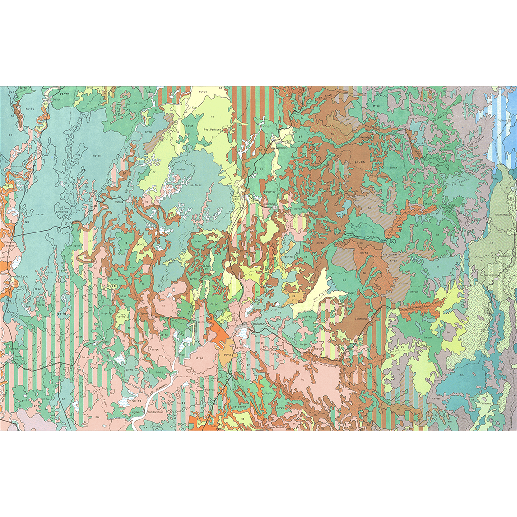
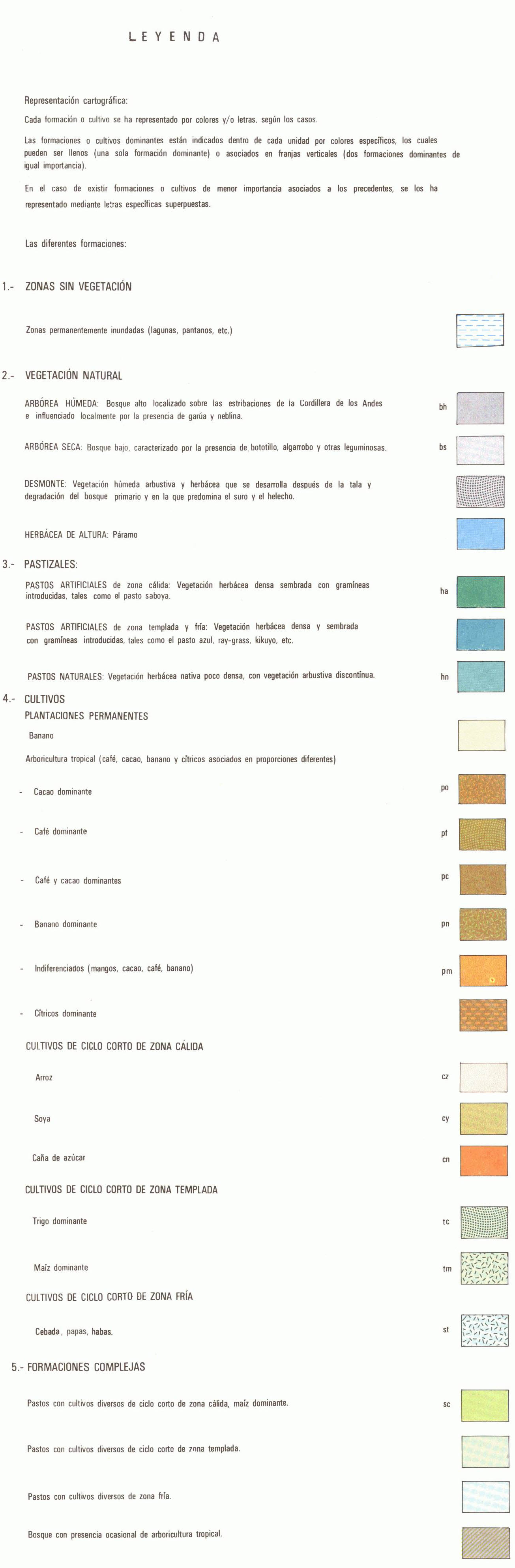
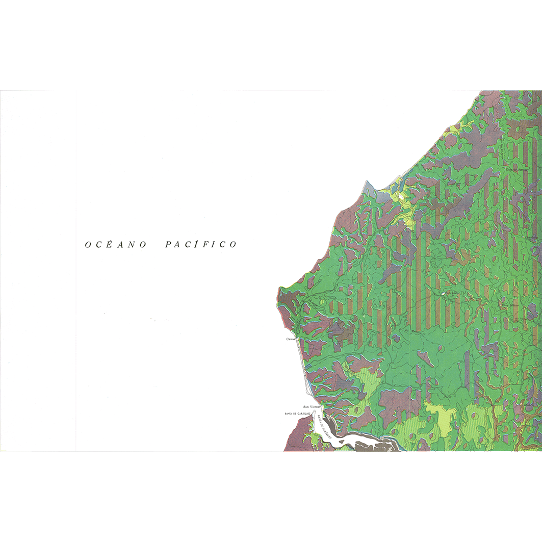
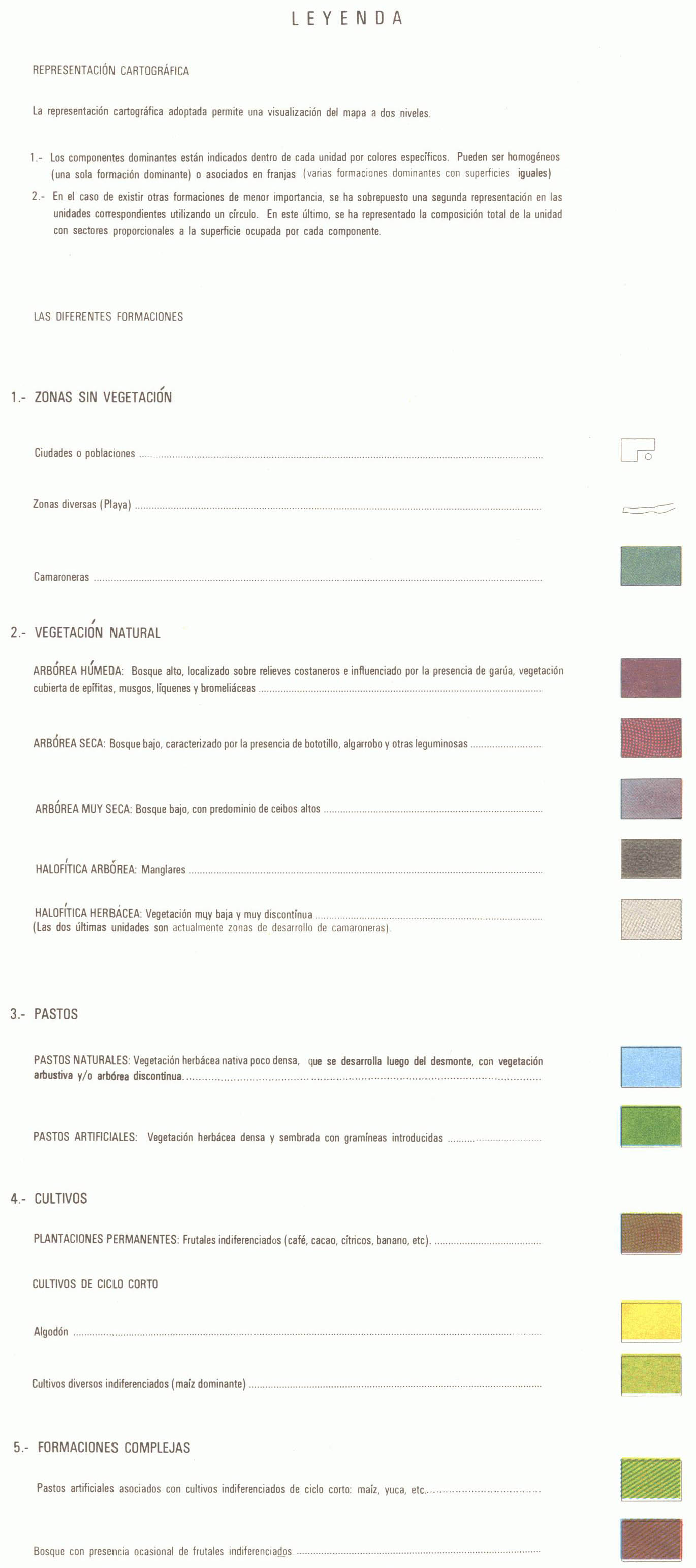
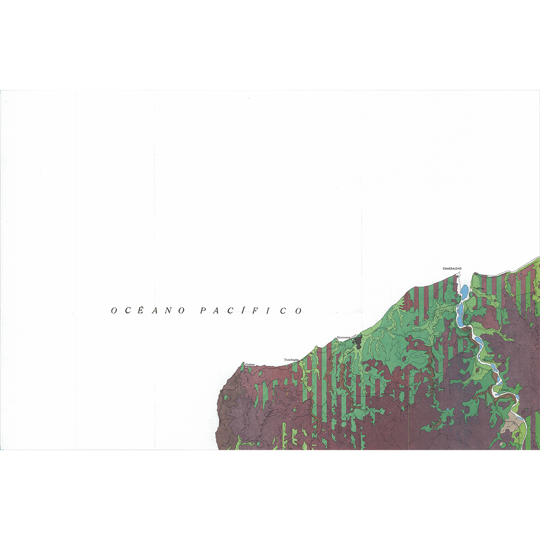
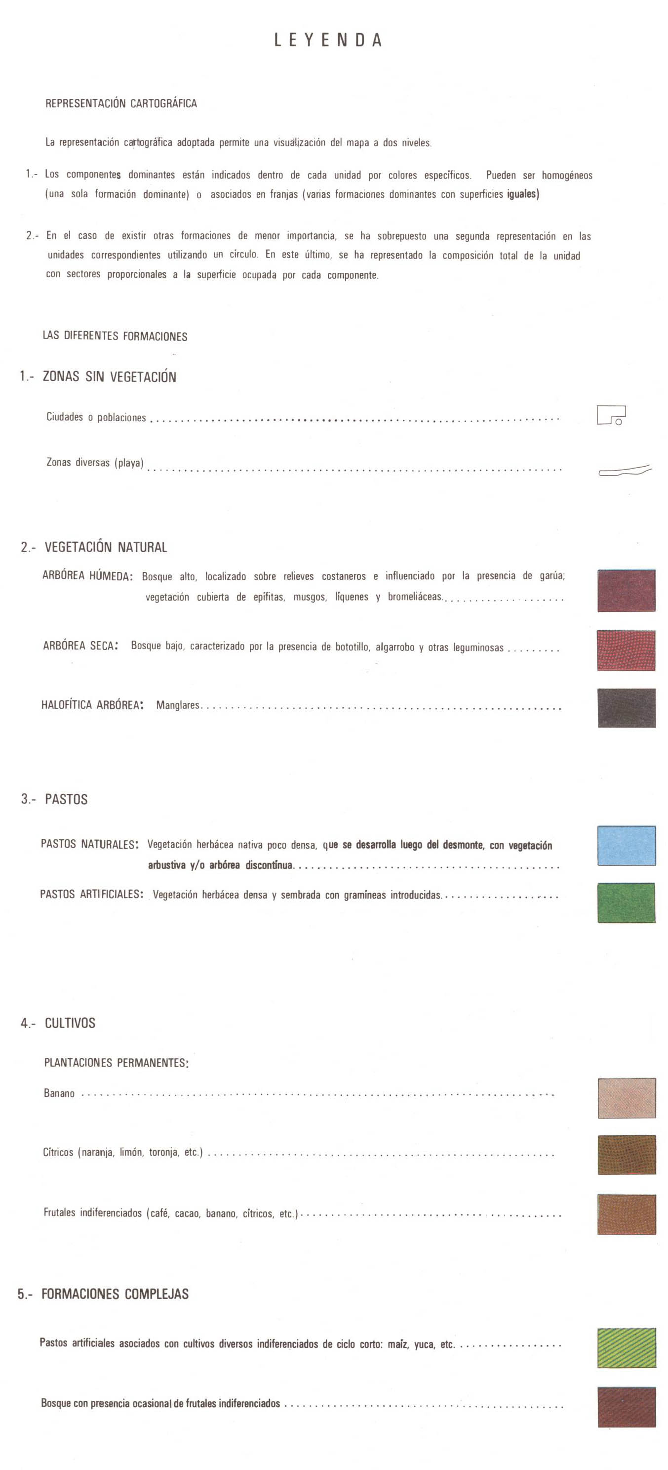
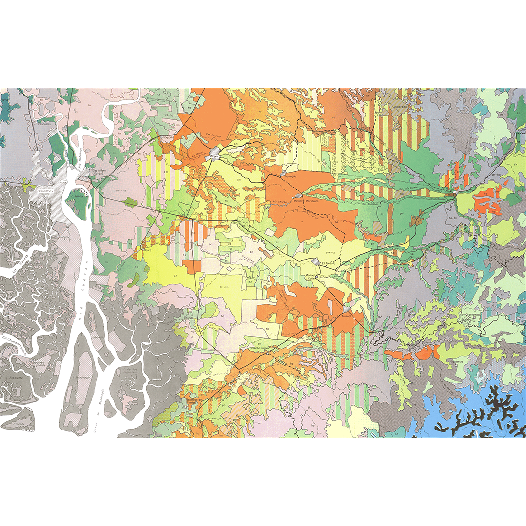
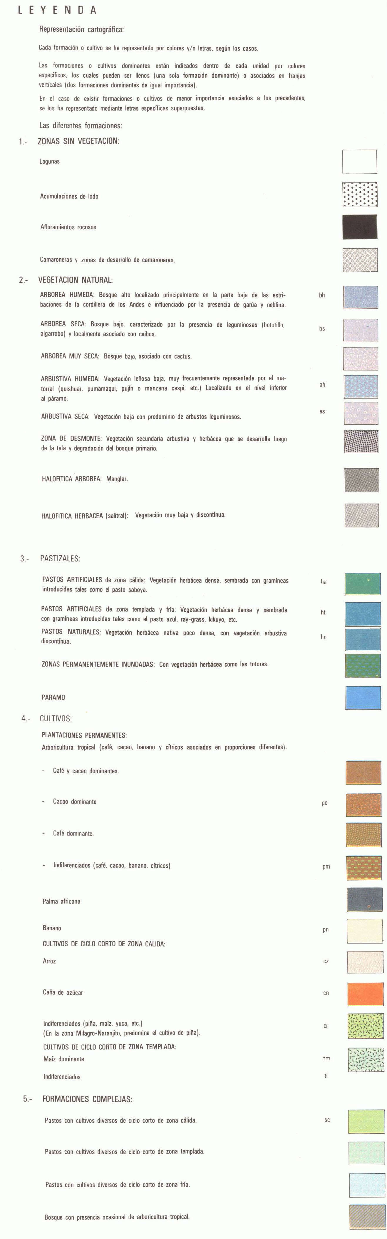
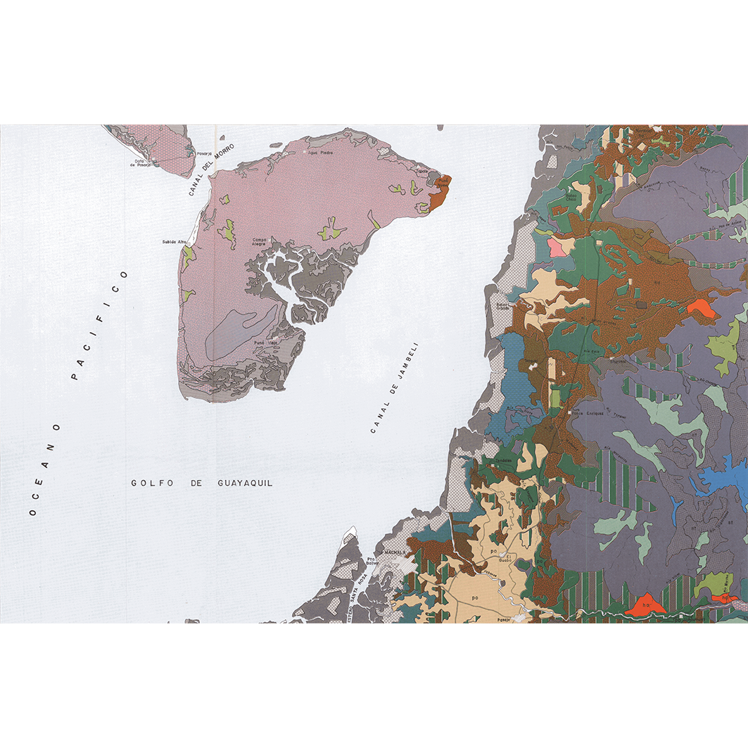
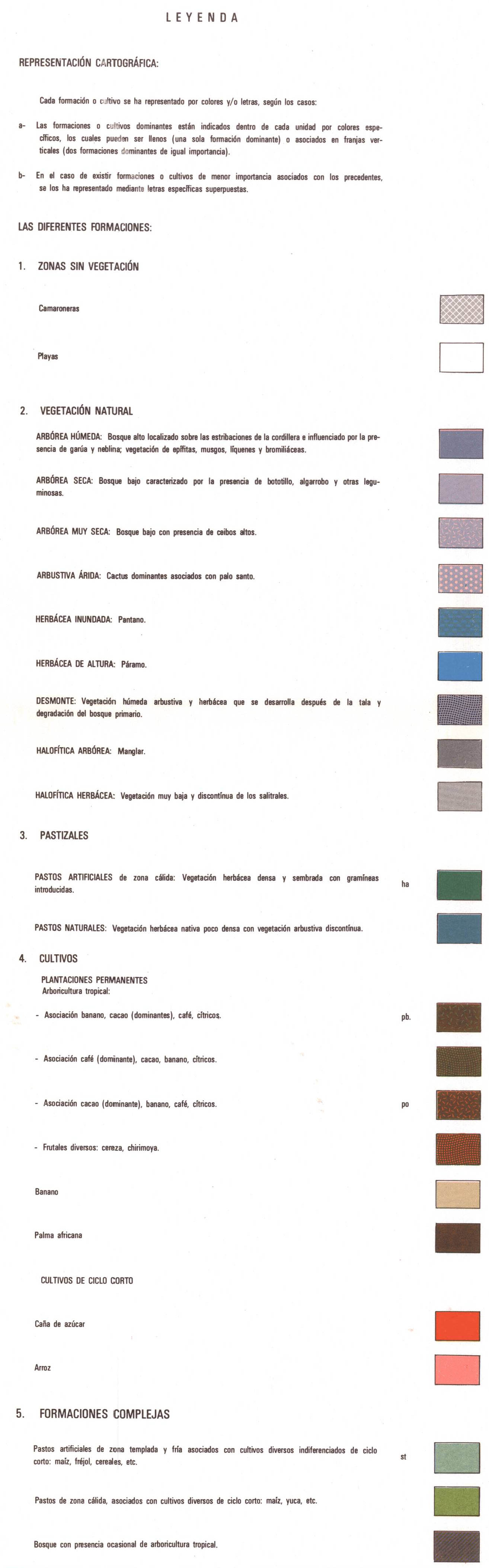
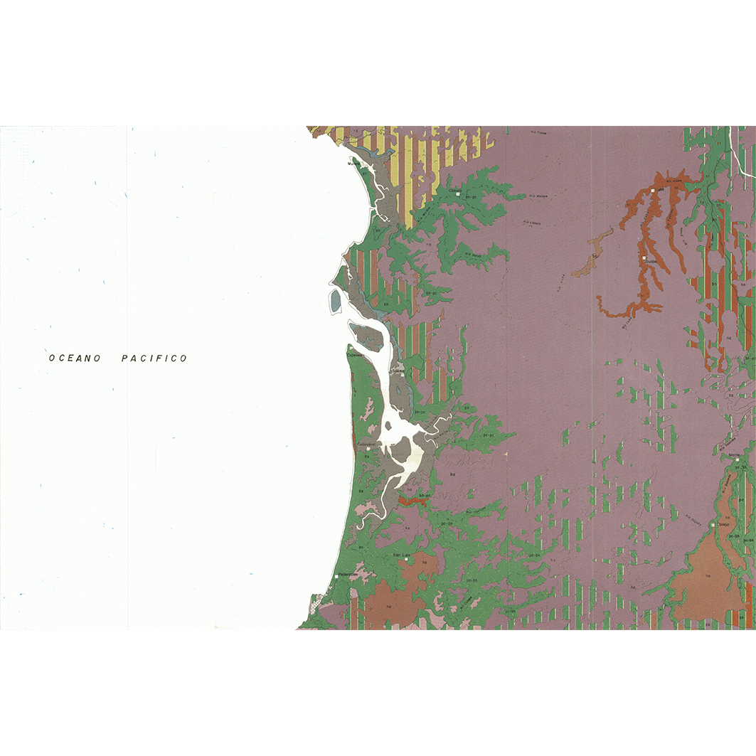
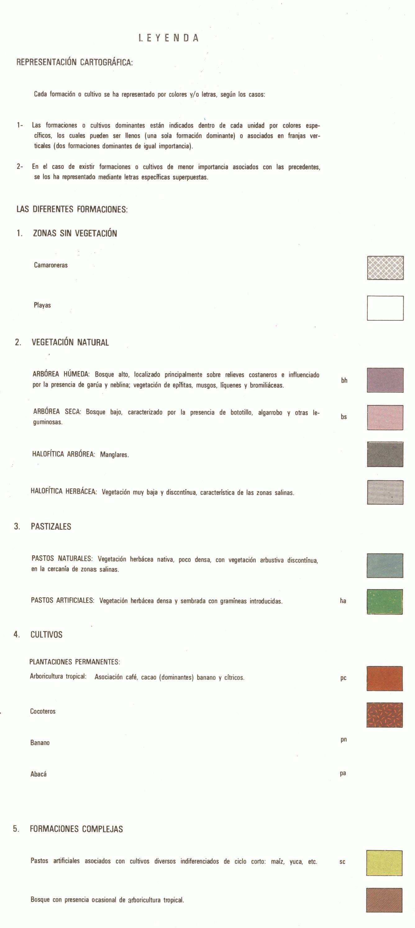
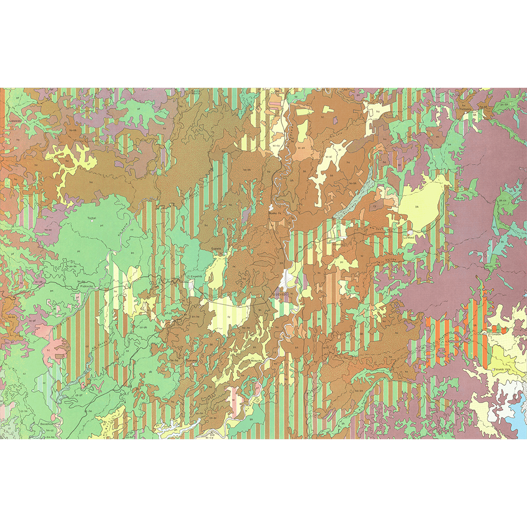
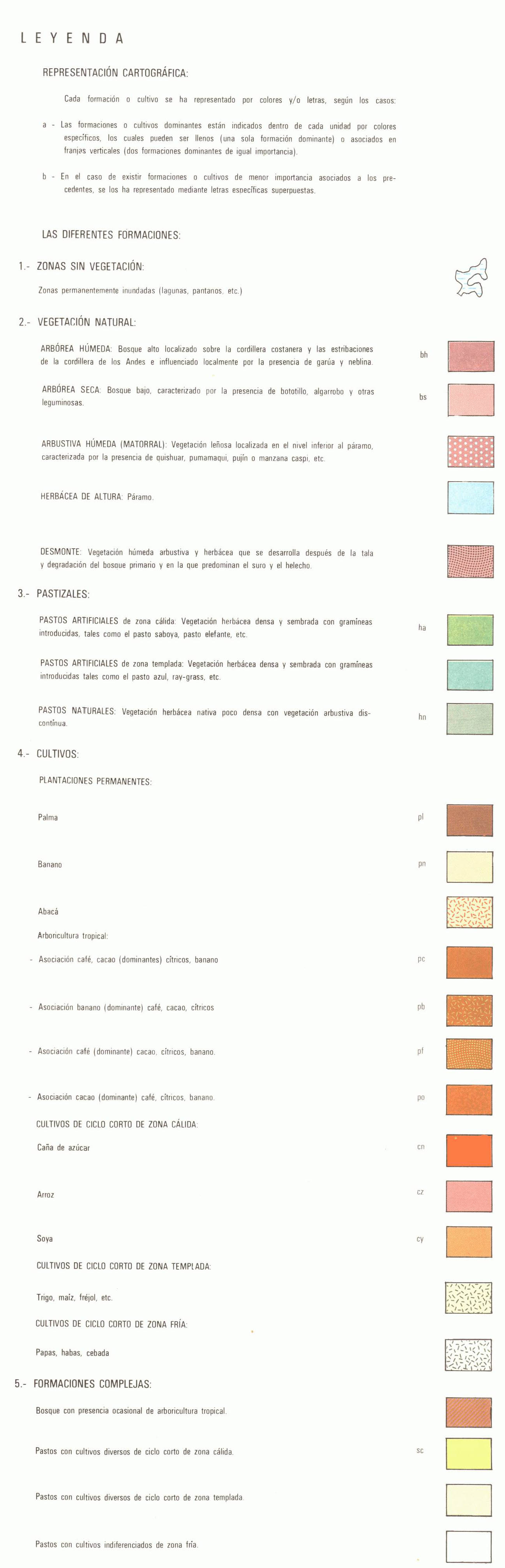
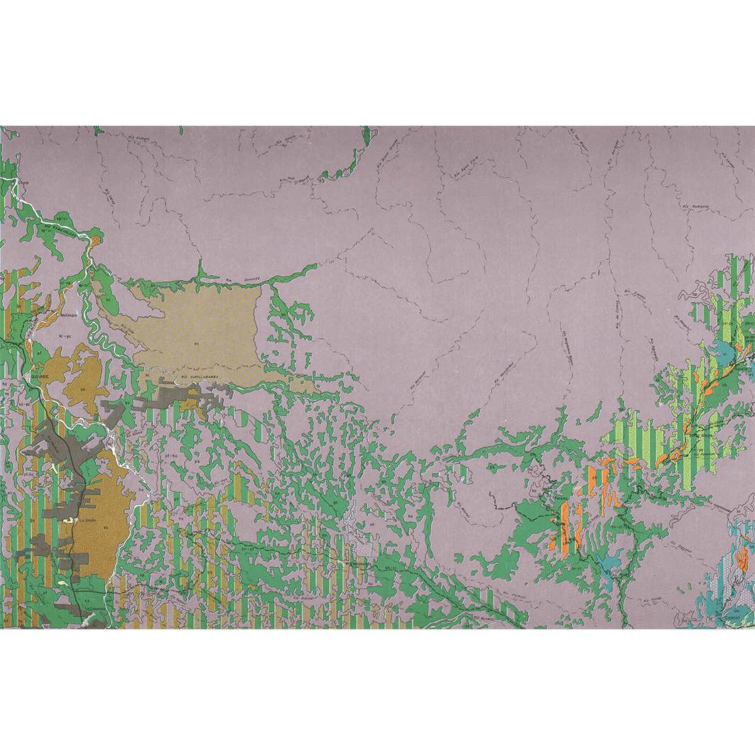
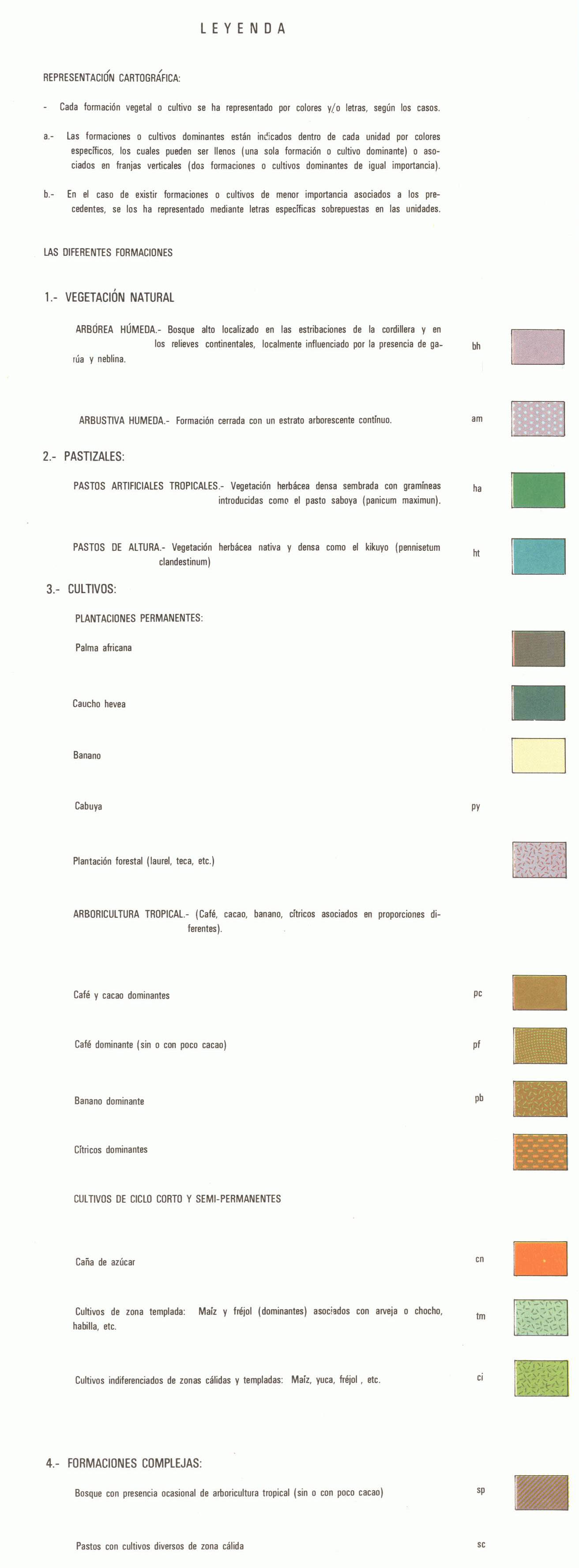
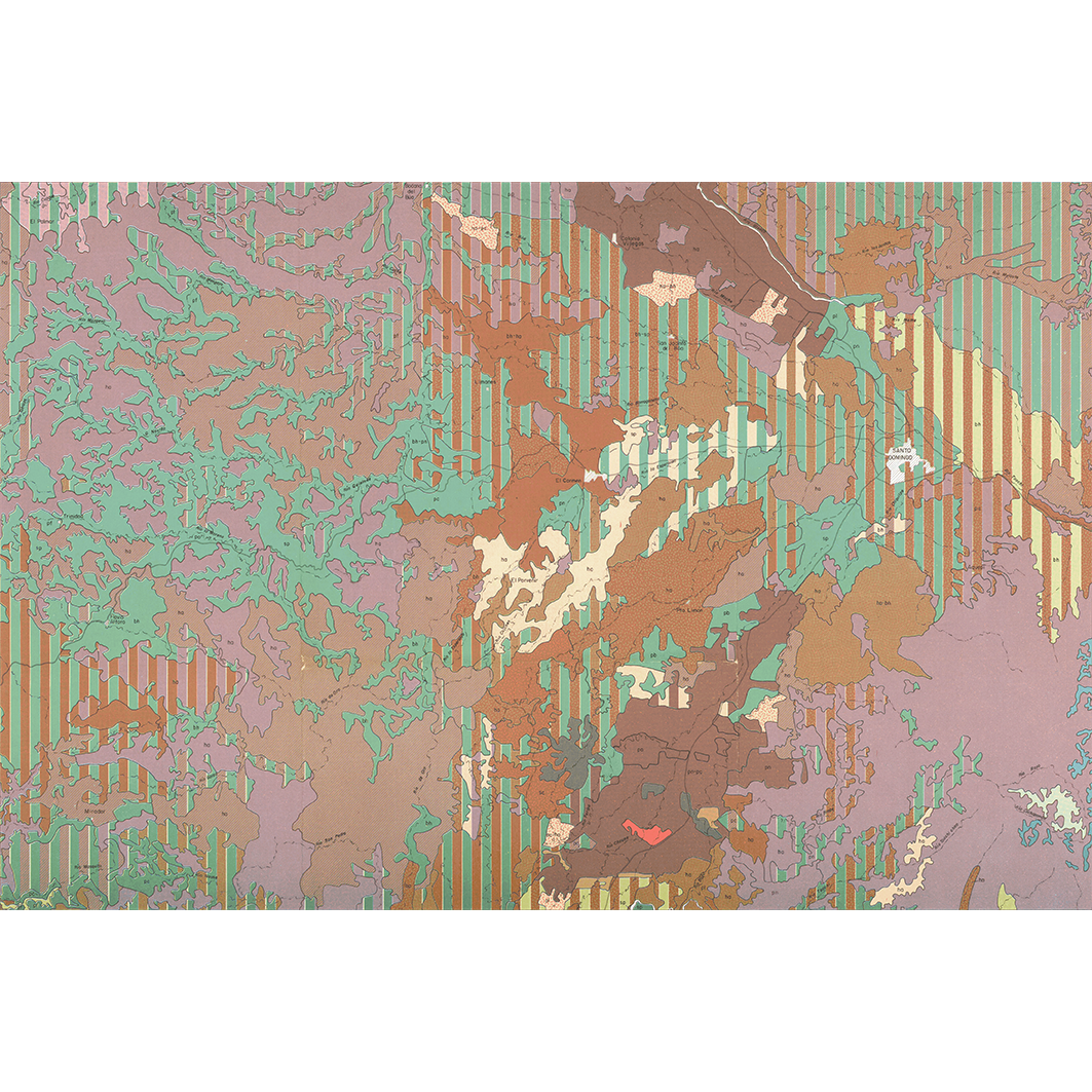
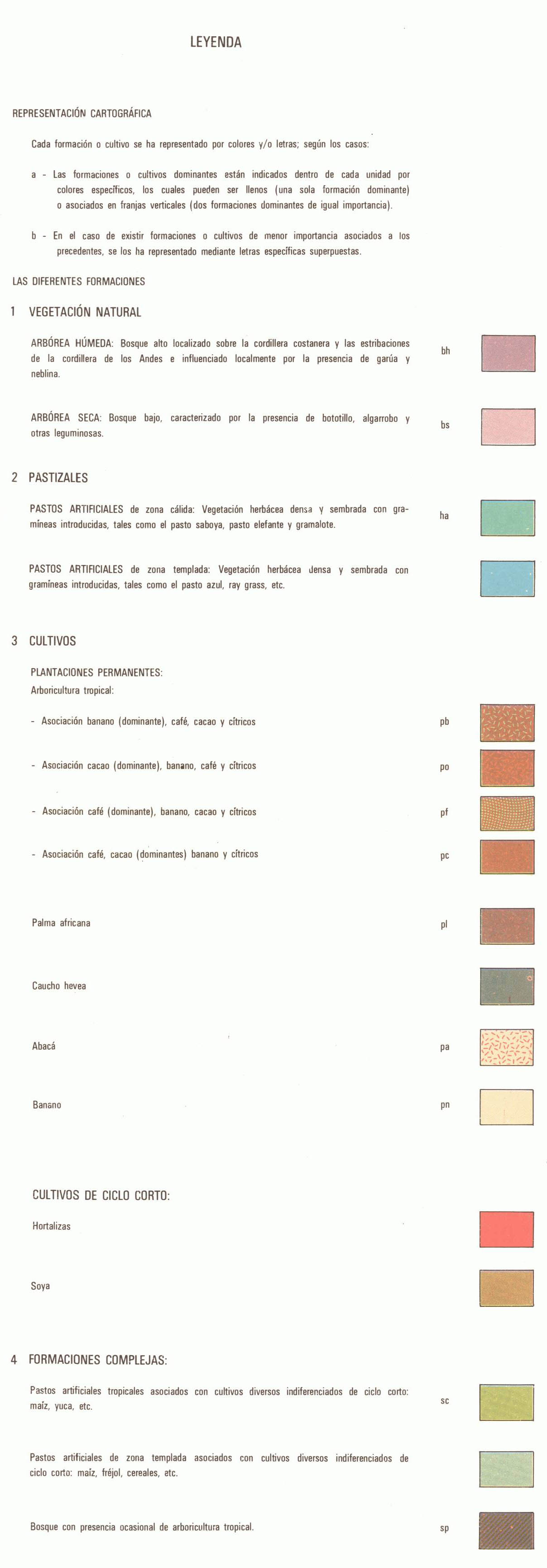
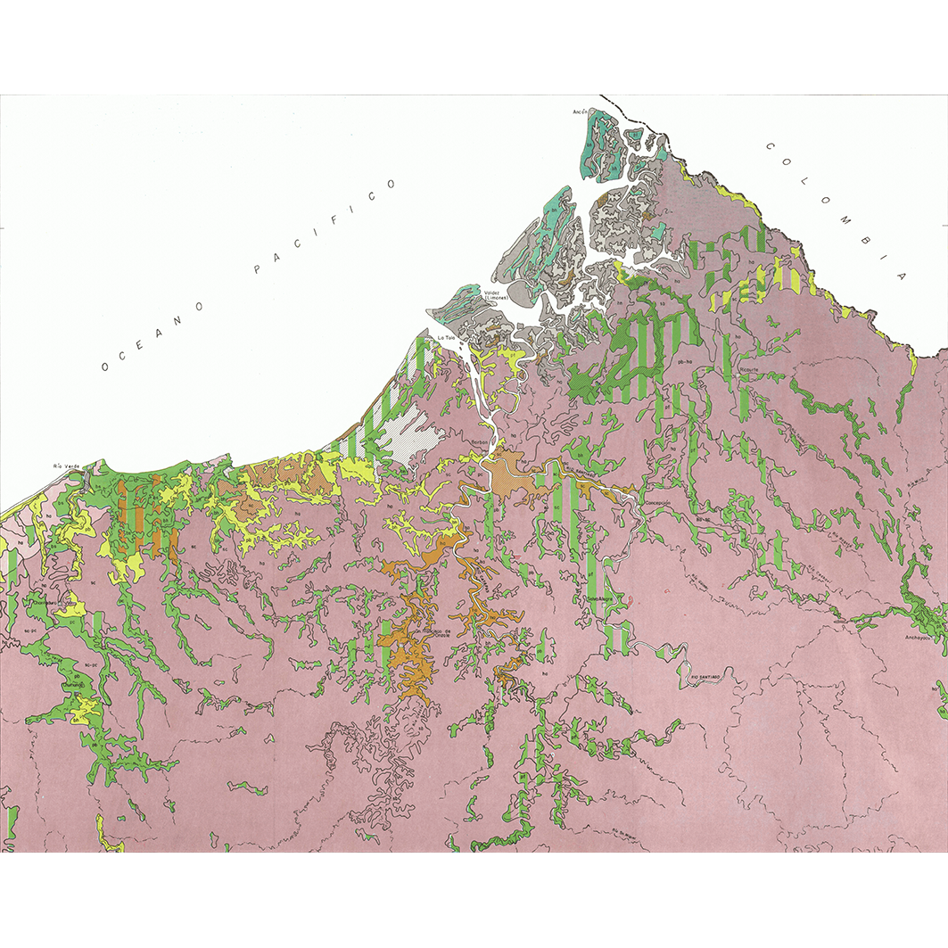
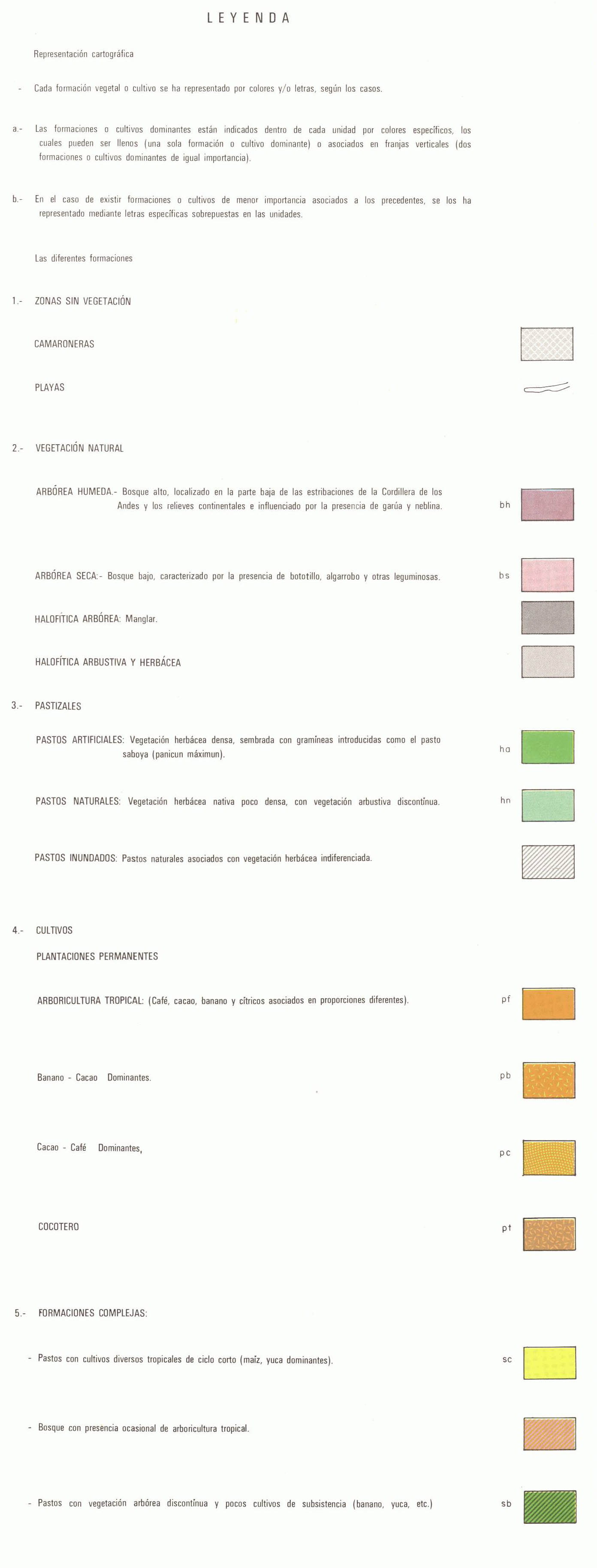
Équateur : mapa de formaciones vegetales y uso actual. Scale of 1:200 000. Date of publication: 1982-1984.
1. Babahoyo : mapa de formaciones vegetales y uso actual. / La Torre S., Patricio de; Miranda R., Jaime; Muñoz F., Alfredo; Tipantuña A., Gustavo; Winckell, A.; Zebrowski, C.; Zuñiga N., Marcelo; Scale of 1:200 000. Date of publication: 1984. (file: 02475RC_IRD_ECU_VEFO_1984_200000_IRD_ECU_VEFO_1982-84_200000.tif)
2. Bahia de Caraquez : mapa de formaciones vegetales y uso actual. / La Torre S., Patricio de; Muñoz F., Alfredo; Paredes D., Luis; Tipantuña A., Gustavo; Winckell, A.; Zebrowski, C.; Scale of 1:200 000. Date of publication: 1982. (file: 02490RC_IRD_ECU_VEFO_1982_200000_IRD_ECU_VEFO_1982-84_200000.tif)
3. Esmeraldas : mapa de formaciones vegetales y uso actual. / La Torre S., Patricio de; Benitez, Miguel E.; Manrique Y., Galo; Trujillo Y., German; Winckell, A.; Zebrowski, C.; Zuñiga N., Marcelo; Scale of 1:200 000. Date of publication: 1982. (file: 02484RC_IRD_ECU_VEFO_1982_200000_IRD_ECU_VEFO_1982-84_200000.tif)
4. Guayaquil : mapa de formaciones vegetales y uso actual. / La Torre S., Patricio de; Miranda R., Jaime; Muñoz F., Alfredo; Winckell, A.; Zebrowski, C.; Scale of 1:200 000. Date of publication: 1984. (file: 02478RC_IRD_ECU_VEFO_1984_200000_IRD_ECU_VEFO_1982-84_200000.tif)
5. Machala : mapa de formaciones vegetales y uso actual. / La Torre S., Patricio de; Calero J., Carlos; Huttel, Ch.; Winckell, A.; Zebrowski, C.; Zuñiga N., Marcelo; Scale of 1:200 000. Date of publication: 1983. (file: 02481RC_IRD_ECU_VEFO_1983_200000_IRD_ECU_VEFO_1982-84_200000.tif)
6. Muisne : mapa de formaciones vegetales y uso actual. / Manrique Y., Galo; Coronel A., Jaime; La Torre S., Patricio de; Muñoz F., Alfredo; Winckell, A.; Zebrowski, C.; Zuñiga N., Marcelo; Scale of 1:200 000. Date of publication: 1983. (file: 02487RC_IRD_ECU_VEFO_1983_200000_IRD_ECU_VEFO_1982-84_200000.tif)
7. Quevedo : mapa de formaciones vegetales y uso actual. / La Torre S., Patricio de; Huttel, Ch.; Miranda R., Jaime; Muñoz F., Alfredo; Tipantuña A., Gustavo; Winckell, A.; Zebrowski, C.; Zuñiga N., Marcelo; Scale of 1:200 000. Date of publication: 1984. (file: 02472RC_IRD_ECU_VEFO_1984_200000_IRD_ECU_VEFO_1982-84_200000.tif)
8. Quinindé : mapa de formaciones vegetales y uso actual. / Loaiza, César; La Torre S., Patricio de; Tipantuña A., Gustavo; Winckell, A.; Zebrowski, C.; Scale of 1:200 000. Date of publication: 1984. (file: 02466RC_IRD_ECU_VEFO_1984_200000_IRD_ECU_VEFO_1982-84_200000.tif)
9. Santo Domingo : mapa de formaciones vegetales y uso actual. / La Torre S., Patricio de; Huttel, Ch.; Miranda R., Jaime; Muñoz F., Alfredo; Tipantuña A., Gustavo; Winckell, A.; Zebrowski, C.; Zuñiga N., Marcelo; Scale of 1:200 000. Date of publication: 1983. (file: 02469RC_IRD_ECU_VEFO_1983_200000_IRD_ECU_VEFO_1982-84_200000.tif)
10. Valdez : mapa de formaciones vegetales y uso actual. / La Torre S., Patricio de; Miranda R., Jaime; Muñoz F., Alfredo; Winckell, A.; Zebrowski, C.; Zuñiga N., Marcelo; Scale of 1:200 000. Date of publication: 1984. (file: 02463RC_IRD_ECU_VEFO_1984_200000_IRD_ECU_VEFO_1982-84_200000.tif)
Simple
- Date (Publication)
- 1982-01-01
- Citation identifier
- IRD_ECU_VEFO_1982-84_200000
- Credit
-
The region Île-de-France, under the project NumeriSud, supported the action to transforme around 2800 maps that are conserved at the Institut de recherche pour le développement (IRD) library in Bondy into a standard coordinate system. The transformation of the images has been done by Global Mapping Resources (South Africa) under the supervision of R. Zaiss (éditeur) 2014.
- Status
- Completed
- Point of contact
-
Organisation name Individual name Electronic mail address Role Institut de recherche pour le développement (IRD)
Production cartographique IRD
Point of contact La Torre S., Patricio de
Author Loaiza, César
Author Manrique Y., Galo
Author Benitez, Miguel E.
Author Calero J., Carlos
Author Coronel A., Jaime
Author Huttel, Ch.
Author Miranda R., Jaime
Author Muñoz F., Alfredo
Author Paredes D., Luis
Author Tipantuña A., Gustavo
Author Trujillo Y., German
Author Winckell, A.
Author Zebrowski, C.
Author Zuñiga N., Marcelo
Author MAG, Ministerio de agricultura y ganaderia, PRONAREG. Programa nacional de regionalizacion agraria
editor ORSTOM, Office de la recherche scientifique et technique outre-mer
editor
- Maintenance and update frequency
- Not planned
-
Geounits
-
-
Americas
-
South America
-
Ecuador
-
- Theme
-
-
thematic map
-
- Keywords
-
-
project NumeriSud
-
local coverage
-
labex CEBA
-
- Use limitation
-
Licence : CC-BY-NC-SA
- Access constraints
- licence
- Classification
- Unclassified
- Spatial representation type
- Grid
- Denominator
- 200000
- Language
- Français
- Character set
- UTF8
- Topic category
-
- Biota
))
- Begin date
- 1982-01-01
- End date
- 1984-12-31
- Supplemental Information
-
Publication(s):
Huttel, C.; Winckell, A., Zebrowski, C., La Torre, P., Tipantuña, A., G., Zuñiga, M., Muñoz, A., Miranda, J. (1984): Quevedo : mapa de formaciones vegetales y uso actual. Quito (ECU) : MAG, Ministerio de agricultura y ganaderia, PRONAREG. Programa nacional de regionalizacion agraria ; Quito (ECU) : ORSTOM, Office de la recherche scientifique et technique outre mer.
La Torre S. P., Loaiza, C., Tipantuña, A., G., Winckell, A., Zebrowski, C. (1984): Quinindé : mapa de formaciones vegetales y uso actual. Quito (ECU) : MAG, Ministerio de agricultura y ganaderia, PRONAREG. Programa nacional de regionalizacion agraria ; Quito (ECU) : ORSTOM, Office de la recherche scientifique et technique outre mer.
La Torre S. P., Zebrowski, C., Coronel, J., Muñoz, A., Zuñiga, M., Manrique Y., Winckell, A. (1983): Muisne : mapa de formaciones vegetales y uso actual. Quito (ECU) : MAG, Ministerio de agricultura y ganaderia, PRONAREG. Programa nacional de regionalizacion agraria ; Quito (ECU) : ORSTOM, Office de la recherche scientifique et technique outre mer.
Manrique, G., Trujillo, G., Benitez, M. E., La Torre, P., Winckell, A., Zuñiga, M., Zebrowski, C. (1982): Esmeraldas : mapa de formaciones vegetales y uso actual. Quito (ECU) : MAG, Ministerio de agricultura y ganaderia, PRONAREG. Programa nacional de regionalizacion agraria ; Quito (ECU) : ORSTOM, Office de la recherche scientifique et technique outre mer.
Miranda, J., Zebrowski, C., La Torre, P., Winckell, A., Zuñiga, M., Muñoz, A. (1984): Valdez : mapa de formaciones vegetales y uso actual. Quito (ECU) : MAG, Ministerio de agricultura y ganaderia, PRONAREG. Programa nacional de regionalizacion agraria ; Quito (ECU) : ORSTOM, Office de la recherche scientifique et technique outre mer.
Tipantuña, G., Miranda, J., La Torre S., P., Zebrowski, C., Winckell, A., Zuñiga, M., Muñoz, A. (1984): Babahoyo : mapa de formaciones vegetales y uso actual. Quito (ECU) : MAG, Ministerio de agricultura y ganaderia, PRONAREG. Programa nacional de regionalizacion agraria ; Quito (ECU) : ORSTOM, Office de la recherche scientifique et technique outre mer.
Winckell, A., La Torre, P., Zuñiga, M., Zebrowski, C., Huttel, C., Calero J. (1983): Machala : mapa de formaciones vegetales y uso actual. Quito (ECU) : MAG, Ministerio de agricultura y ganaderia, PRONAREG. Programa nacional de regionalizacion agraria ; Quito (ECU) : ORSTOM, Office de la recherche scientifique et technique outre mer.
Zebrowski, C., La Torre, P., Winckell, A., Tipantuña, A., G., Muñoz, A., Parades, L. (1982): Bahia de Caraquez : mapa de formaciones vegetales y uso actual. Quito (ECU) : MAG, Ministerio de agricultura y ganaderia, PRONAREG. Programa nacional de regionalizacion agraria ; Quito (ECU) : ORSTOM, Office de la recherche scientifique et technique outre mer.
Zebrowski, C., Winckell, A., La Torre, P., Miarnda, J., Muñoz, A., Zuñiga, M., Tipantuña, A., G., Huttel, C. (1983): Santo Domingo : mapa de formaciones vegetales y uso actual. Quito (ECU) : MAG, Ministerio de agricultura y ganaderia, PRONAREG. Programa nacional de regionalizacion agraria ; Quito (ECU) : ORSTOM, Office de la recherche scientifique et technique outre mer.
Zebrowski, C., Winckell, A., Muñoz, A., Miranda, J., La Torre S., P. (1984): Guayaquil : mapa de formaciones vegetales y uso actual. Quito (ECU) : MAG, Ministerio de agricultura y ganaderia, PRONAREG. Programa nacional de regionalizacion agraria ; Quito (ECU) : ORSTOM, Office de la recherche scientifique et technique outre mer.
- Reference system identifier
- EPSG / 4326 / 7.9
- Distribution format
-
Name Version GeoTIFF
1.0
- Distributor contact
-
Organisation name Individual name Electronic mail address Role DataSuds-geo
Publisher
- OnLine resource
-
Protocol Linkage Name OGC:WMS
https://datasuds-geo.ird.fr/geoserver/wms sphaera_ws:02475RC_IRD_ECU_VEFO_1984_200000_IRD_ECU_VEFO_1982-84_200000
WWW:DOWNLOAD:GeoTIFF https://datasuds-geo.ird.fr/geoserver/ows?service=WCS&version=2.0.1&request=GetCoverage&coverageId=02475RC_IRD_ECU_VEFO_1984_200000_IRD_ECU_VEFO_1982-84_200000
- OnLine resource
-
Protocol Linkage Name OGC:WMS
https://datasuds-geo.ird.fr/geoserver/wms sphaera_ws:02490RC_IRD_ECU_VEFO_1982_200000_IRD_ECU_VEFO_1982-84_200000
WWW:DOWNLOAD:GeoTIFF https://datasuds-geo.ird.fr/geoserver/ows?service=WCS&version=2.0.1&request=GetCoverage&coverageId=02490RC_IRD_ECU_VEFO_1982_200000_IRD_ECU_VEFO_1982-84_200000
- OnLine resource
-
Protocol Linkage Name OGC:WMS
https://datasuds-geo.ird.fr/geoserver/wms sphaera_ws:02484RC_IRD_ECU_VEFO_1982_200000_IRD_ECU_VEFO_1982-84_200000
WWW:DOWNLOAD:GeoTIFF https://datasuds-geo.ird.fr/geoserver/ows?service=WCS&version=2.0.1&request=GetCoverage&coverageId=02484RC_IRD_ECU_VEFO_1982_200000_IRD_ECU_VEFO_1982-84_200000
- OnLine resource
-
Protocol Linkage Name OGC:WMS
https://datasuds-geo.ird.fr/geoserver/wms sphaera_ws:02478RC_IRD_ECU_VEFO_1984_200000_IRD_ECU_VEFO_1982-84_200000
WWW:DOWNLOAD:GeoTIFF https://datasuds-geo.ird.fr/geoserver/ows?service=WCS&version=2.0.1&request=GetCoverage&coverageId=02478RC_IRD_ECU_VEFO_1984_200000_IRD_ECU_VEFO_1982-84_200000
- OnLine resource
-
Protocol Linkage Name OGC:WMS
https://datasuds-geo.ird.fr/geoserver/wms sphaera_ws:02481RC_IRD_ECU_VEFO_1983_200000_IRD_ECU_VEFO_1982-84_200000
WWW:DOWNLOAD:GeoTIFF https://datasuds-geo.ird.fr/geoserver/ows?service=WCS&version=2.0.1&request=GetCoverage&coverageId=02481RC_IRD_ECU_VEFO_1983_200000_IRD_ECU_VEFO_1982-84_200000
- OnLine resource
-
Protocol Linkage Name OGC:WMS
https://datasuds-geo.ird.fr/geoserver/wms sphaera_ws:02487RC_IRD_ECU_VEFO_1983_200000_IRD_ECU_VEFO_1982-84_200000
WWW:DOWNLOAD:GeoTIFF https://datasuds-geo.ird.fr/geoserver/ows?service=WCS&version=2.0.1&request=GetCoverage&coverageId=02487RC_IRD_ECU_VEFO_1983_200000_IRD_ECU_VEFO_1982-84_200000
- OnLine resource
-
Protocol Linkage Name OGC:WMS
https://datasuds-geo.ird.fr/geoserver/wms sphaera_ws:02472RC_IRD_ECU_VEFO_1984_200000_IRD_ECU_VEFO_1982-84_200000
WWW:DOWNLOAD:GeoTIFF https://datasuds-geo.ird.fr/geoserver/ows?service=WCS&version=2.0.1&request=GetCoverage&coverageId=02472RC_IRD_ECU_VEFO_1984_200000_IRD_ECU_VEFO_1982-84_200000
- OnLine resource
-
Protocol Linkage Name OGC:WMS
https://datasuds-geo.ird.fr/geoserver/wms sphaera_ws:02466RC_IRD_ECU_VEFO_1984_200000_IRD_ECU_VEFO_1982-84_200000
WWW:DOWNLOAD:GeoTIFF https://datasuds-geo.ird.fr/geoserver/ows?service=WCS&version=2.0.1&request=GetCoverage&coverageId=02466RC_IRD_ECU_VEFO_1984_200000_IRD_ECU_VEFO_1982-84_200000
- OnLine resource
-
Protocol Linkage Name OGC:WMS
https://datasuds-geo.ird.fr/geoserver/wms sphaera_ws:02469RC_IRD_ECU_VEFO_1983_200000_IRD_ECU_VEFO_1982-84_200000
WWW:DOWNLOAD:GeoTIFF https://datasuds-geo.ird.fr/geoserver/ows?service=WCS&version=2.0.1&request=GetCoverage&coverageId=02469RC_IRD_ECU_VEFO_1983_200000_IRD_ECU_VEFO_1982-84_200000
- OnLine resource
-
Protocol Linkage Name OGC:WMS
https://datasuds-geo.ird.fr/geoserver/wms sphaera_ws:02463RC_IRD_ECU_VEFO_1984_200000_IRD_ECU_VEFO_1982-84_200000
WWW:DOWNLOAD:GeoTIFF https://datasuds-geo.ird.fr/geoserver/ows?service=WCS&version=2.0.1&request=GetCoverage&coverageId=02463RC_IRD_ECU_VEFO_1984_200000_IRD_ECU_VEFO_1982-84_200000
- OnLine resource
-
Protocol Linkage Name DOI
https://doi.org/10.23708/9005a041-b1a9-465c-89c9-ee7ae220ffb5 Digital Object Identifier (DOI)
- Hierarchy level
- Dataset
- Statement
-
1. Scanning to tif format, 256 colors, 250dpi.
2. Georeferencing and if possible reprojection to WGS84 (Longitude / Latitude).
3. Clipping and mosaicing of map sheets(s).
4. Export ECW format.
5. ECW to GeoTIFF format conversion.
Metadata
- File identifier
- 9005a041-b1a9-465c-89c9-ee7ae220ffb5 XML
- Metadata language
- English
- Character set
- UTF8
- Hierarchy level
- Dataset
- Hierarchy level name
-
dataset
- Date stamp
- 2024-02-13T18:40:26.115388Z
- Metadata standard name
-
ISO 19115:2003/19139
- Metadata standard version
-
1.0
- Metadata author
-
Organisation name Individual name Electronic mail address Role Institut de recherche pour le développement (IRD)
Service de l'Information Scientifique et Technique (IST) IRD
Point of contact Institut de recherche pour le développement (IRD)
IRD
Resource provider
Overviews
Spatial extent
Provided by
