 DataSuds-geo
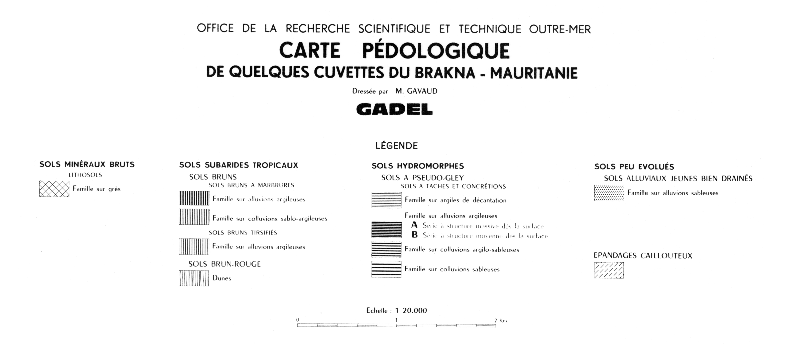
Carte pédologique de quelques cuvettes du Brakna, Mauritanie. Scale of 1:20 000 to 1:10 000. Date of publication: 1959.
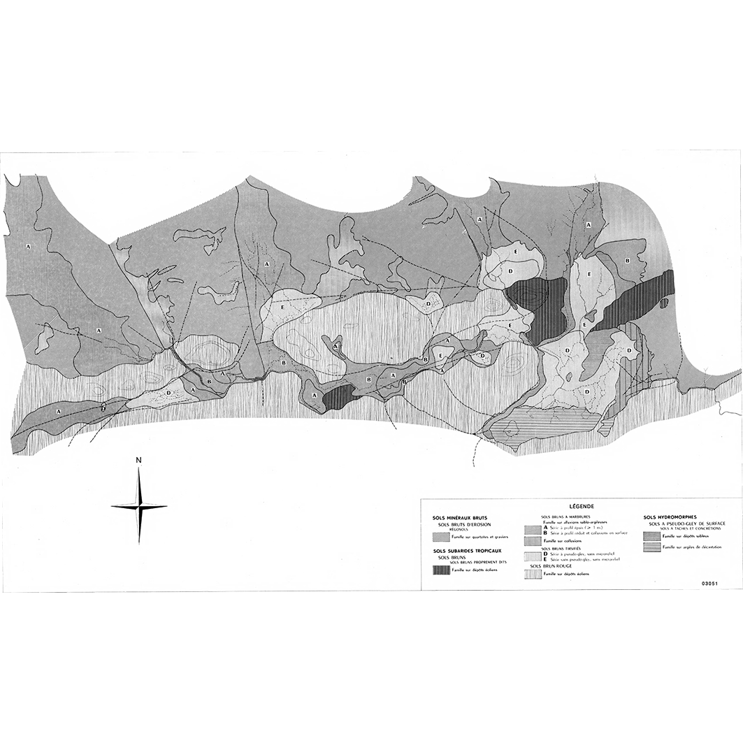
1. Carte pédologique de quelques cuvettes du Brakna, Mauritanie : Chogar. / Gavaud, M.; Scale of 1:20 000. Date of publication: 1959. (file: 03051RC_IRD_MRT_PEDO_1959_20000_IRD_MRT_PEDO_1959_20000-10000.tif)
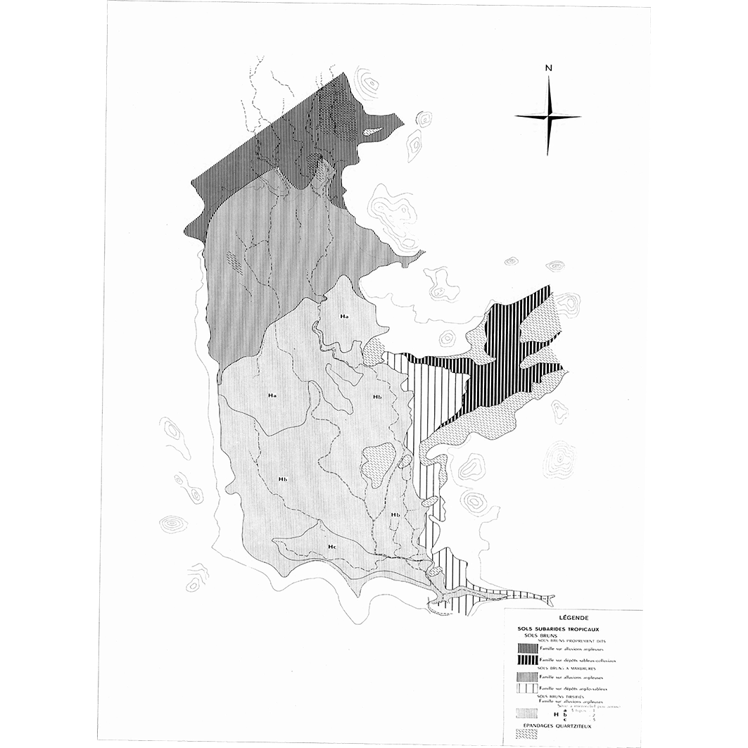
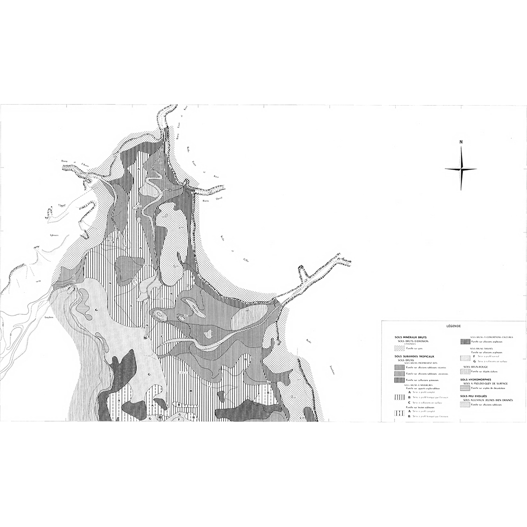
2. Carte pédologique de quelques cuvettes du Brakna, Mauritanie : Dionaba. / Gavaud, M.; Scale of 1:10 000. Date of publication: 1959. (file: 03055RC_IRD_MRT_PEDO_1959_10000_IRD_MRT_PEDO_1959_20000-10000.tif)
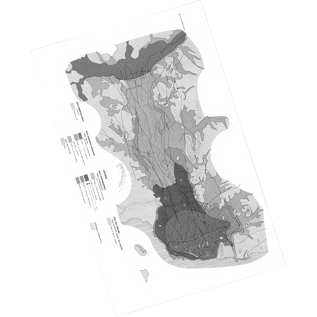
3. Carte pédologique de quelques cuvettes du Brakna, Mauritanie : Gadel. / Gavaud, M.; Scale of 1:20 000. Date of publication: 1959. (file: 03052RC_IRD_MRT_PEDO_1959_20000_IRD_MRT_PEDO_1959_20000-10000.tif)
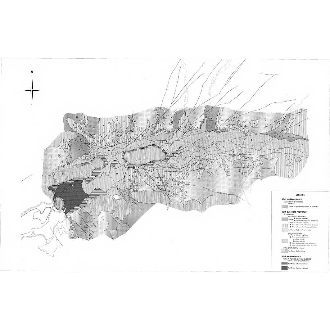
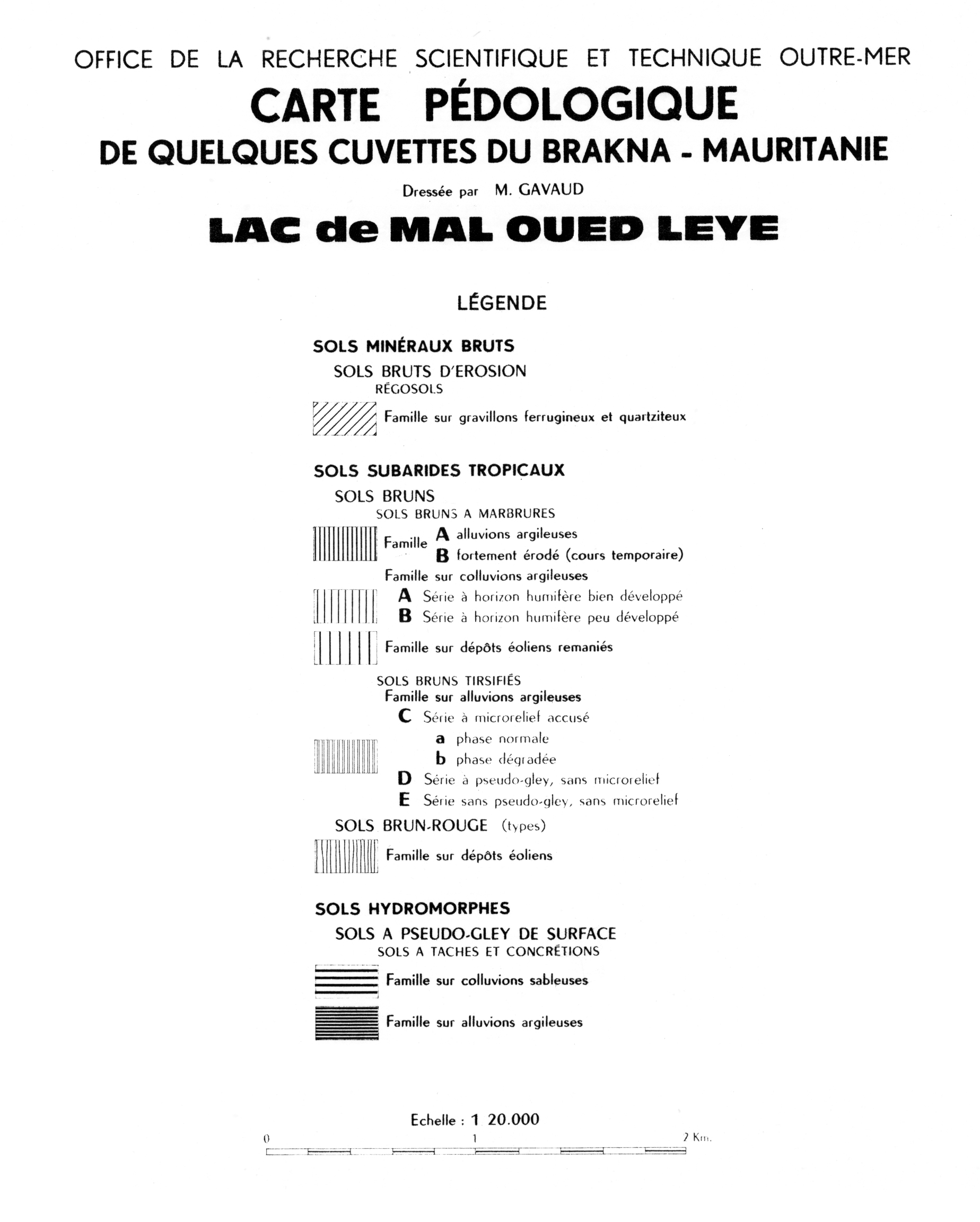
4. Carte pédologique de quelques cuvettes du Brakna, Mauritanie : lac de Mal Oued Leye. / Gavaud, M.; Scale of 1:20 000. Date of publication: 1959. (file: 03053RC_IRD_MRT_PEDO_1959_20000_IRD_MRT_PEDO_1959_20000-10000.tif)
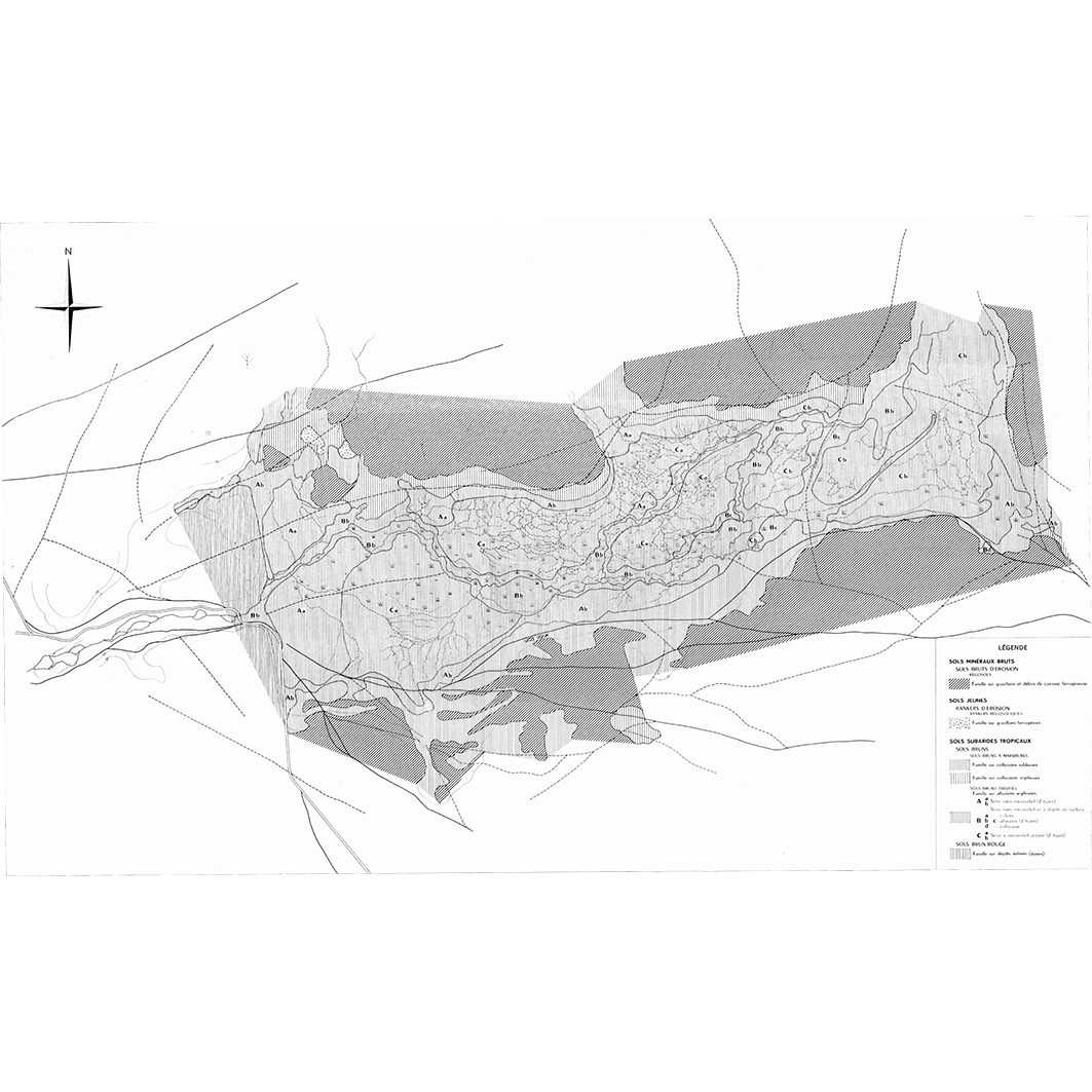
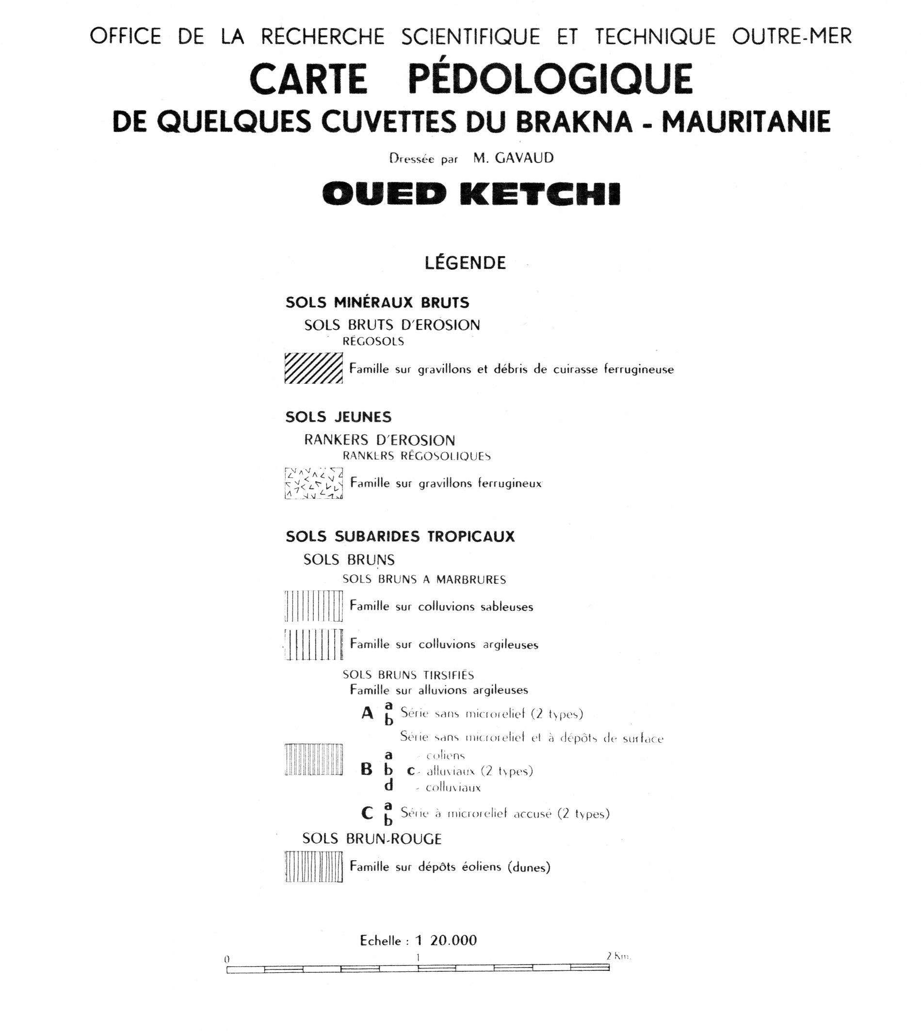
5. Carte pédologique de quelques cuvettes du Brakna, Mauritanie : oued Ketchi. / Gavaud, M.; Scale of 1:20 000. Date of publication: 1959. (file: 03054RC_IRD_MRT_PEDO_1959_20000_IRD_MRT_PEDO_1959_20000-10000.tif)
6. Carte pédologique de quelques cuvettes du Brakna, Mauritanie : Tamourt en Nage (nord). / Gavaud, M.; Scale of 1:20 000. Date of publication: 1959. (file: 02954RC_IRD_MRT_PEDO_1959_20000_IRD_MRT_PEDO_1959_20000-10000.tif)
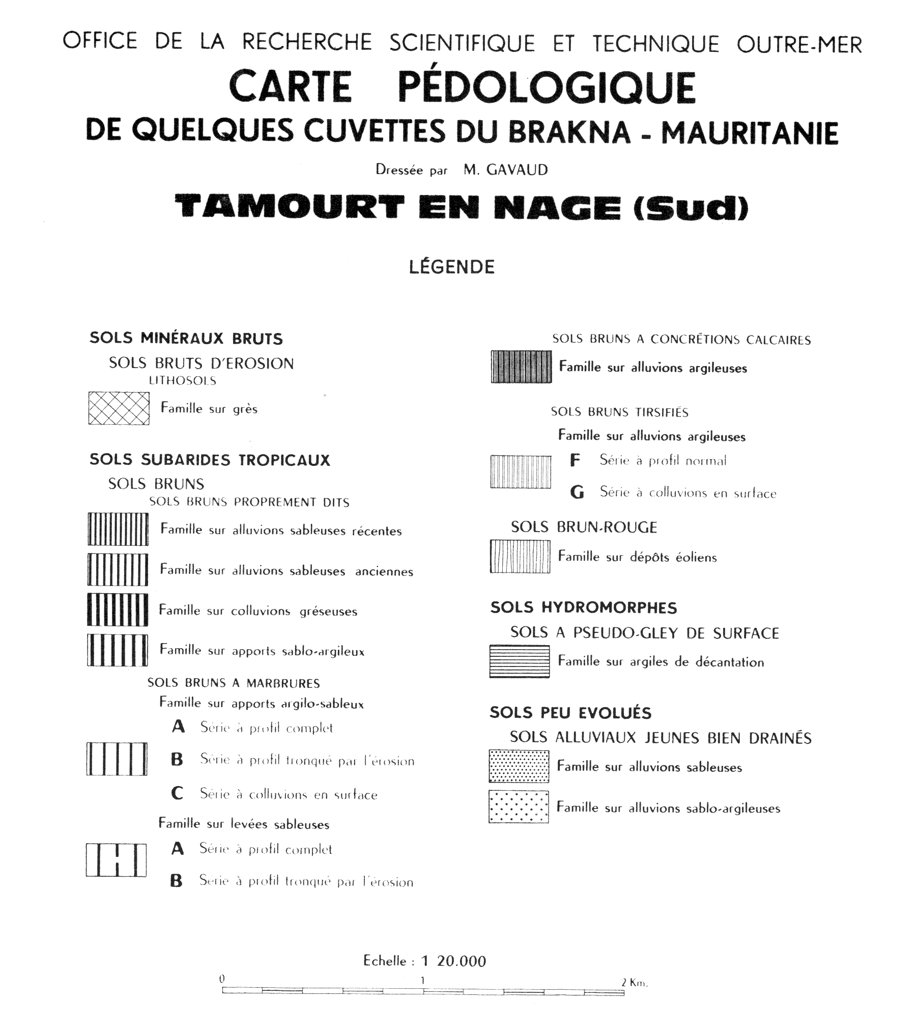
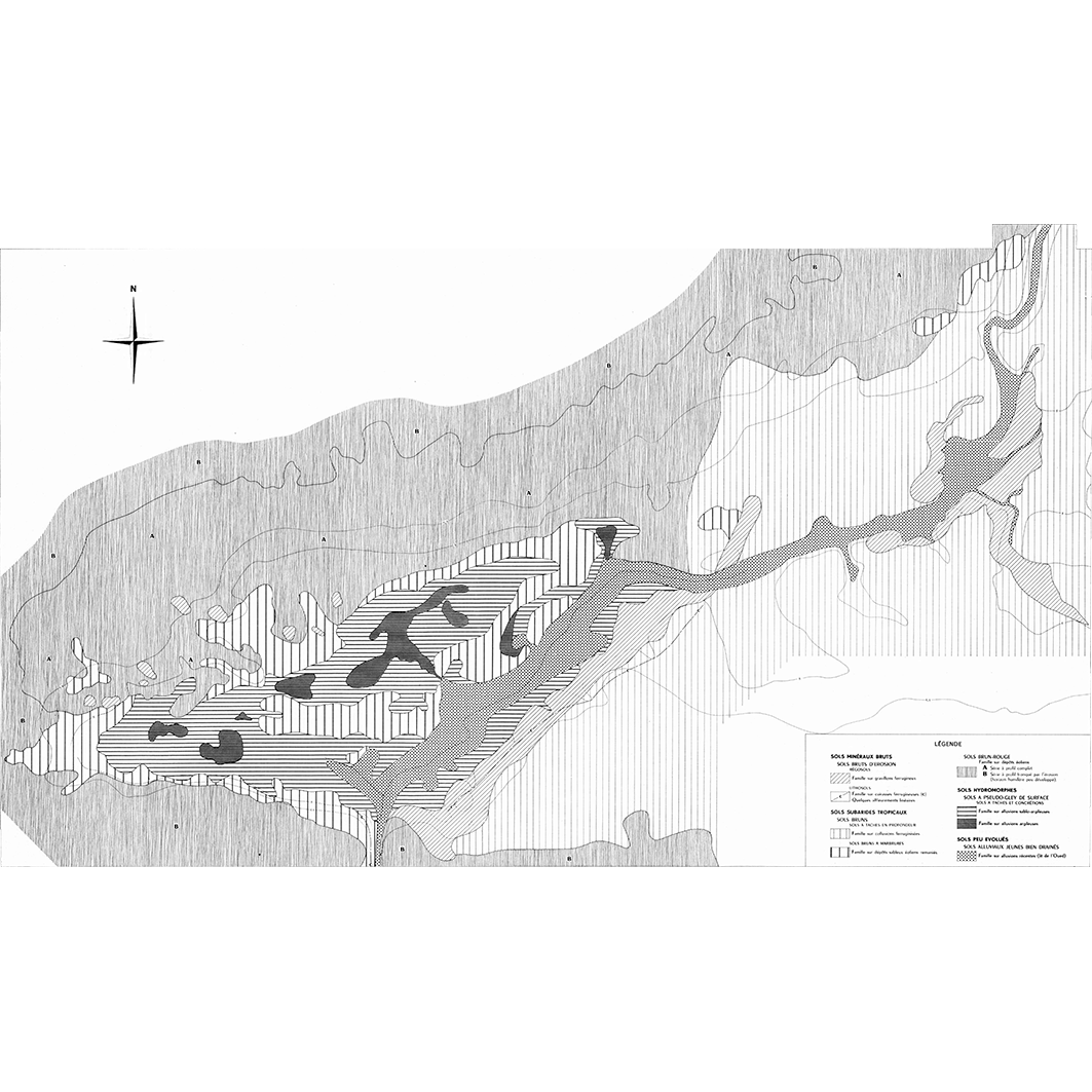
7. Carte pédologique de quelques cuvettes du Brakna, Mauritanie : Tamourt en Nage (sud). / Gavaud, M.; Scale of 1:20 000. Date of publication: 1959. (file: 02955RC_IRD_MRT_PEDO_1959_20000_IRD_MRT_PEDO_1959_20000-10000.tif)
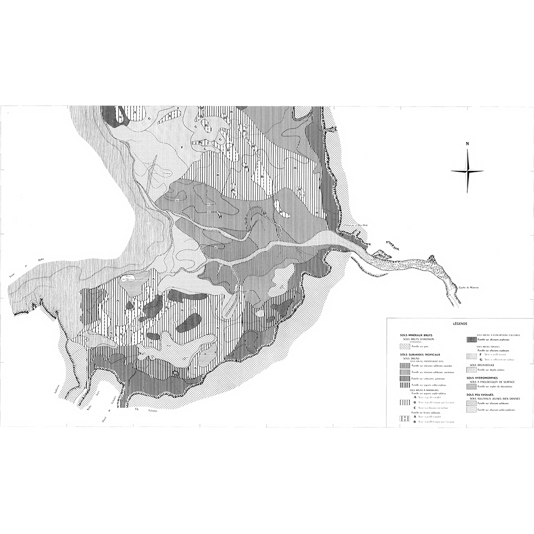
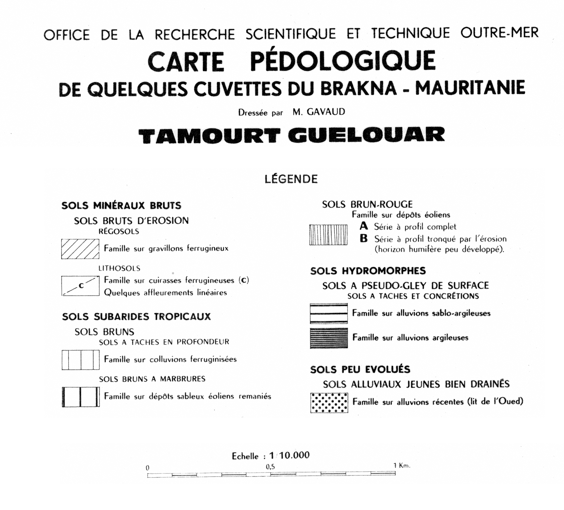
8. Carte pédologique de quelques cuvettes du Brakna, Mauritanie : Tamourt Guélouar. / Gavaud, M.; Scale of 1:10 000. Date of publication: 1959. (file: 03056RC_IRD_MRT_PEDO_1959_10000_IRD_MRT_PEDO_1959_20000-10000.tif)
Simple
- Date (Publication)
- 1959-01-01
- Citation identifier
- IRD_MRT_PEDO_1959_20000-10000
- Credit
-
The region Île-de-France, under the project NumeriSud, supported the action to transforme around 2800 maps that are conserved at the Institut de recherche pour le développement (IRD) library in Bondy into a standard coordinate system. The transformation of the images has been done by Global Mapping Resources (South Africa) under the supervision of R. Zaiss (éditeur) 2014.
- Status
- Completed
- Point of contact
-
Organisation name Individual name Electronic mail address Role Institut de recherche pour le développement (IRD)
Production cartographique IRD
Point of contact Gavaud, M.
Author ORSTOM, Office de la recherche scientifique et technique outre-mer, Centre pédologique
editor
- Maintenance and update frequency
- Not planned
-
Geounits
-
-
Africa
-
Western Africa
-
Mauritania
-
- Theme
-
-
thematic map
-
- Keywords
-
-
project NumeriSud
-
local coverage
-
- Use limitation
-
Licence : CC-BY-NC-SA
- Access constraints
- licence
- Classification
- Unclassified
- Spatial representation type
- Grid
- Denominator
- 10000
- Language
- Français
- Character set
- UTF8
- Topic category
-
- Geoscientific information
))
))
))
))
))
))
))
- Begin date
- 1959-01-01
- End date
- 1959-12-31
- Supplemental Information
-
Publication(s):
Gavaud, M. (1959): Carte pédologique de quelques cuvettes du Brakna, Mauritanie : Chogar. Hann Dakar (SEN) : ORSTOM, Office de la recherche scientifique et technique outre mer, Centre pédologique.
Gavaud, M. (1959): Carte pédologique de quelques cuvettes du Brakna, Mauritanie : Dionaba. Hann Dakar (SEN) : ORSTOM, Office de la recherche scientifique et technique outre mer, Centre pédologique.
Gavaud, M. (1959): Carte pédologique de quelques cuvettes du Brakna, Mauritanie : Gadel. Hann Dakar (SEN) : ORSTOM, Office de la recherche scientifique et technique outre mer, Centre pédologique.
Gavaud, M. (1959): Carte pédologique de quelques cuvettes du Brakna, Mauritanie : lac de Mal Oued Leye. Hann Dakar (SEN) : ORSTOM, Office de la recherche scientifique et technique outre mer, Centre pédologique.
Gavaud, M. (1959): Carte pédologique de quelques cuvettes du Brakna, Mauritanie : oued Ketchi. Hann Dakar (SEN) : ORSTOM, Office de la recherche scientifique et technique outre mer, Centre pédologique.
Gavaud, M. (1959): Carte pédologique de quelques cuvettes du Brakna, Mauritanie : Tamourt en Nage (nord). Hann Dakar (SEN) : ORSTOM, Office de la recherche scientifique et technique outre mer, Centre pédologique.
Gavaud, M. (1959): Carte pédologique de quelques cuvettes du Brakna, Mauritanie : Tamourt en Nage (sud). Hann Dakar (SEN) : ORSTOM, Office de la recherche scientifique et technique outre mer, Centre pédologique.
Gavaud, M. (1959): Carte pédologique de quelques cuvettes du Brakna, Mauritanie : Tamourt Guélouar. Hann Dakar (SEN) : ORSTOM, Office de la recherche scientifique et technique outre mer, Centre pédologique.
- Reference system identifier
- EPSG / 4326 / 7.9
- Distribution format
-
Name Version GeoTIFF
1.0
- Distributor contact
-
Organisation name Individual name Electronic mail address Role DataSuds-geo
Publisher
- OnLine resource
-
Protocol Linkage Name OGC:WMS
https://datasuds-geo.ird.fr/geoserver/wms sphaera_ws:03051RC_IRD_MRT_PEDO_1959_20000_IRD_MRT_PEDO_1959_20000-10000
WWW:DOWNLOAD:GeoTIFF https://datasuds-geo.ird.fr/geoserver/ows?service=WCS&version=2.0.1&request=GetCoverage&coverageId=03051RC_IRD_MRT_PEDO_1959_20000_IRD_MRT_PEDO_1959_20000-10000
- OnLine resource
-
Protocol Linkage Name OGC:WMS
https://datasuds-geo.ird.fr/geoserver/wms sphaera_ws:03055RC_IRD_MRT_PEDO_1959_10000_IRD_MRT_PEDO_1959_20000-10000
WWW:DOWNLOAD:GeoTIFF https://datasuds-geo.ird.fr/geoserver/ows?service=WCS&version=2.0.1&request=GetCoverage&coverageId=03055RC_IRD_MRT_PEDO_1959_10000_IRD_MRT_PEDO_1959_20000-10000
- OnLine resource
-
Protocol Linkage Name OGC:WMS
https://datasuds-geo.ird.fr/geoserver/wms sphaera_ws:03052RC_IRD_MRT_PEDO_1959_20000_IRD_MRT_PEDO_1959_20000-10000
WWW:DOWNLOAD:GeoTIFF https://datasuds-geo.ird.fr/geoserver/ows?service=WCS&version=2.0.1&request=GetCoverage&coverageId=03052RC_IRD_MRT_PEDO_1959_20000_IRD_MRT_PEDO_1959_20000-10000
- OnLine resource
-
Protocol Linkage Name OGC:WMS
https://datasuds-geo.ird.fr/geoserver/wms sphaera_ws:03053RC_IRD_MRT_PEDO_1959_20000_IRD_MRT_PEDO_1959_20000-10000
WWW:DOWNLOAD:GeoTIFF https://datasuds-geo.ird.fr/geoserver/ows?service=WCS&version=2.0.1&request=GetCoverage&coverageId=03053RC_IRD_MRT_PEDO_1959_20000_IRD_MRT_PEDO_1959_20000-10000
- OnLine resource
-
Protocol Linkage Name OGC:WMS
https://datasuds-geo.ird.fr/geoserver/wms sphaera_ws:03054RC_IRD_MRT_PEDO_1959_20000_IRD_MRT_PEDO_1959_20000-10000
WWW:DOWNLOAD:GeoTIFF https://datasuds-geo.ird.fr/geoserver/ows?service=WCS&version=2.0.1&request=GetCoverage&coverageId=03054RC_IRD_MRT_PEDO_1959_20000_IRD_MRT_PEDO_1959_20000-10000
- OnLine resource
-
Protocol Linkage Name OGC:WMS
https://datasuds-geo.ird.fr/geoserver/wms sphaera_ws:02954RC_IRD_MRT_PEDO_1959_20000_IRD_MRT_PEDO_1959_20000-10000
WWW:DOWNLOAD:GeoTIFF https://datasuds-geo.ird.fr/geoserver/ows?service=WCS&version=2.0.1&request=GetCoverage&coverageId=02954RC_IRD_MRT_PEDO_1959_20000_IRD_MRT_PEDO_1959_20000-10000
- OnLine resource
-
Protocol Linkage Name OGC:WMS
https://datasuds-geo.ird.fr/geoserver/wms sphaera_ws:02955RC_IRD_MRT_PEDO_1959_20000_IRD_MRT_PEDO_1959_20000-10000
WWW:DOWNLOAD:GeoTIFF https://datasuds-geo.ird.fr/geoserver/ows?service=WCS&version=2.0.1&request=GetCoverage&coverageId=02955RC_IRD_MRT_PEDO_1959_20000_IRD_MRT_PEDO_1959_20000-10000
- OnLine resource
-
Protocol Linkage Name OGC:WMS
https://datasuds-geo.ird.fr/geoserver/wms sphaera_ws:03056RC_IRD_MRT_PEDO_1959_10000_IRD_MRT_PEDO_1959_20000-10000
WWW:DOWNLOAD:GeoTIFF https://datasuds-geo.ird.fr/geoserver/ows?service=WCS&version=2.0.1&request=GetCoverage&coverageId=03056RC_IRD_MRT_PEDO_1959_10000_IRD_MRT_PEDO_1959_20000-10000
- OnLine resource
-
Protocol Linkage Name DOI
https://doi.org/10.23708/c34df557-69c7-4552-b2cd-98902aa28939 Digital Object Identifier (DOI)
- Hierarchy level
- Dataset
- Statement
-
1. Scanning to tif format, 256 colors, 250dpi.
2. Georeferencing and if possible reprojection to WGS84 (Longitude / Latitude).
3. Clipping and mosaicing of map sheets(s).
4. Export ECW format.
5. ECW to GeoTIFF format conversion.
Metadata
- File identifier
- c34df557-69c7-4552-b2cd-98902aa28939 XML
- Metadata language
- English
- Character set
- UTF8
- Hierarchy level
- Dataset
- Hierarchy level name
-
dataset
- Date stamp
- 2024-02-13T16:52:29.693827Z
- Metadata standard name
-
ISO 19115:2003/19139
- Metadata standard version
-
1.0
- Metadata author
-
Organisation name Individual name Electronic mail address Role Institut de recherche pour le développement (IRD)
Service de l'Information Scientifique et Technique (IST) IRD
Point of contact Institut de recherche pour le développement (IRD)
IRD
Resource provider
Overviews

Spatial extent
Provided by
