 DataSuds-geo
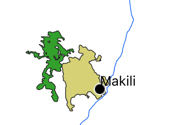
Paysage - Île d'Atauro - Timor oriental - Asie
Landscape- Atauro Island - East Timor - Asia
Les données sont issues d’un séjour de terrain mené par Dominique Guillaud en novembre-décembre 2019, dans le cadre du projet Politiques culturelles, patrimoines locaux et approches collaboratives dans l’Est insulindien—ANR-18-CE27-020 POPEI-COLL. Les données sur le paysage sont centrées sur le village de Makili situé au sud-est de l'ïle d'Atauro (Timor-Leste). Forêt et champs sont cartographiés afin de mieux comprendre les difficultés de la population à faire face aux crises passées et présentes.
The data come from a field trip conducted by Dominique Guillaud in November-December 2019, as part of the project Politiques culturelles, patrimoines locaux et approches collaboratives dans l'Est insulindien-ANR-18-CE27-020 POPEI. The data collected focuses on the village of Makili in the south-east of the island of Atauro (Timor-Leste). The landscape data focuses on the village of Makili in the south-east of the island of Atauro (Timor-Leste). Forest and fields are mapped in order to better understand the population's difficulties in coping with past and present crises.
Simple
-
Date (Publication)Date (Publication)
- 2024-07-24
- Edition
-
IRD
Citation identifier
Identificateur
-
Presentation formForme de la présentation
-
Digital mapCarte numérique
-
ButPurpose
-
Il s'agit de comprendre comment s’expriment les négociations entre clans autour des ressources à travers l’analyse des récits d’origine des clans, les modes d’occupation du territoire et les alliances matrimoniales.
The aim is to understand how negotiations between clans over resources are expressed, through analysis of the clans' stories of origin, modes of land occupation and matrimonial alliances.
-
StatusEtat
-
CompletedFinalisé
- Point of contact
-
Organisation name Individual name Electronic mail address Role UMR PALOC - IRD, MNHN, CNRS - France
Institut de recherche pour le développement
Dominique Guillaud
Dominique Guillaud
Resource providerFournisseurUMR PALOC - IRD, MNHN, CNRS - France
IRD-UMR PALOC
Dominique Guillaud
Elisabeth Habert
AuthorAuteurUMR PALOC - IRD, MNHN, CNRS - France
IRD - UMR PALOC
Elisabeth Habert
Elisabeth Habert
Point of contactPoint de contact
-
Maintenance and update frequencyFréquence de mise à jour
-
Not plannedNon planifiée
- Metadata author
-
Organisation name Individual name Electronic mail address Role UMR PALOC - IRD, MNHN, CNRS - France
IRD - UMR Paloc
Direction UMR Paloc
Dominique Guillaud
Resource providerFournisseurUMR PALOC - IRD, MNHN, CNRS - France
IRD
Elisabeth Habert
Elisabeth Habert
Point of contactPoint de contact
-
ThemeThème
-
-
Paysage, territoire, environnement
Landscape, territory, environment
-
-
PlaceLocalisation
-
-
Timor oriental, Atauro, Makili
Timor oriental, Atauro, Makili
-
-
Access constraintsContraintes d'accès
-
Intellectual property rightsDroit de propriété intellectuelle / Droit patrimonial
-
Use constraintsContraintes d'utilisation
-
CopyrightDroit d’auteur / Droit moral (copyright)
-
Autres contraintesOther constraints
-
Utilisation libre sous réserve de mentionner la source en citant l'origine de la donnée quand elle est utilisée pour une publication : Programme ANR 18-CE27-020 - UMR PALOC - D Guillaud
Free use subject to mentioning the source and citing the origin of the data when used for publication: Programme ANR 18-CE27-020 - UMR PALOC - D. Guillaud
-
Spatial representation typeType de représentation spatiale
-
VectorVecteur
-
DenominatorDénominateur de l'échelle
- 100000
-
LanguageLangue de la ressource
- Français
-
Character setEncodage des caractères
-
UTF8Utf8
-
Topic categoryCatégorie ISO
-
-
SocietySociété
-
- Begin date
- 2019-11-07
- End date
- 2019-12-20
))
-
Reference system identifierNom du système de référence
- WGS 1984 - EPSG 4326WGS 1984 - EPSG 4326
-
Geometric object typeType de géométries des objets
-
SurfacePolygone
-
Geometric object countNombre d'objets géométriques
- 2
- Distribution format
-
Name Version Vecteur ou Shapefile,etc
Vecteur ou Shapefile,etc
Distributor
Distributeur
- Distributor contact
-
Organisation name Individual name Electronic mail address Role DataSuds-geo
IRD
PublisherEditeur (publication)
- Distributor format
-
Name Version Vecteur ou Shapefile
Vecteur ou Shapefile
- OnLine resource
-
Protocol Linkage Name OGC:WMS https://datasuds-geo.ird.fr/geoserver/paloc_ws/wms Makili_Paysage
DOI https://doi.org/10.4000/12xuz Patrimoines et territoires de l’île d’Atauro (Timor-Est)
DOI https://doi.org/10.4000/12xv4 Le traitement du végétal à Atauro (Timor-Est)
Plants of Atauro: Insights into Biodiversity and Local Knowledge
OGC:WFS https://datasuds-geo.ird.fr/geoserver/paloc_ws/wfs paloc_ws:Makili_Paysage
- OnLine resource
-
Protocol Linkage Name DOI
https://doi.org/10.23708/c92115d3-f58e-42e2-b7b4-3d84529fd26f Digital Object Identifier (DOI)
-
Hierarchy levelNiveau
-
DatasetJeu de données
-
Généralités sur la provenanceStatement
-
Les données sont issues d’un séjour de terrain mené par Dominique Guillaud en novembre-décembre 2019, dans le cadre du projet Politiques culturelles, patrimoines locaux et approches collaboratives dans l’Est insulindien—ANR-18-CE27-020 POPEI-COLL.
Il s'agit de comprendre comment s’expriment les négociations entre clans autour des ressources à travers l’analyse des récits d’origine des clans, les modes d’occupation du territoire et les alliances matrimoniales.
The data come from a field trip conducted by Dominique Guillaud in November-December 2019, as part of the project Politiques culturelles, patrimoines locaux et approches collaboratives dans l'Est insulindien-ANR-18-CE27-020 POPEI-COLL.
The aim is to understand how negotiations between clans over resources are expressed, through analysis of the clans' stories of origin, modes of land occupation and matrimonial alliances.
Metadata
-
File identifierIdentifiant de la fiche
- c92115d3-f58e-42e2-b7b4-3d84529fd26f XML
-
Metadata languageLangue
- Français
-
Character setJeu de caractères
-
UTF8Utf8
-
Hierarchy levelType de ressource
-
DatasetJeu de données
-
Date stampDate des métadonnées
- 2025-03-13T16:18:04.278164Z
- Metadata standard name
-
ISO 19115:2003/19139
- Metadata standard version
-
1.0
- Metadata author
-
Organisation name Individual name Electronic mail address Role IRD
IRD - UMR PALOC
Direction UMR PALOC
Elisabeth Habert
AuthorAuteurIRD - UMR Paloc
IRD - UMR Paloc
Dominique Guillaud
Dominique Guillaud
PublisherEditeur (publication)
- Other language
-
Language Character encoding EnglishAnglaisUTF8Utf8FrenchFrançaisUTF8Utf8
Overviews
Spatial extent
Provided by
