 DataSuds-geo
La sierra équatorienne : régionalisation et analyse des données. Scale of 1:1 000 000 to 1:750 000. Date of publication: 1984-1986.
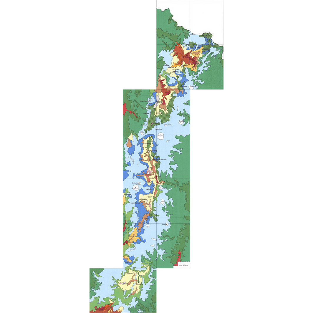
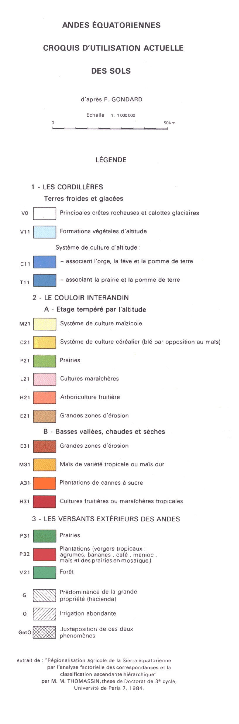
1. Andes équatoriennes : croquis d'utilisation actuelle des sols. / Gondard, P.; Valton, C. (ill.); Scale of 1:1 000 000. Date of publication: 1986. (file: 01365RC_IRD_ECU_USOL_1986_1000000_IRD_ECU_CSRE_1984-86_1000000-750000.tif)
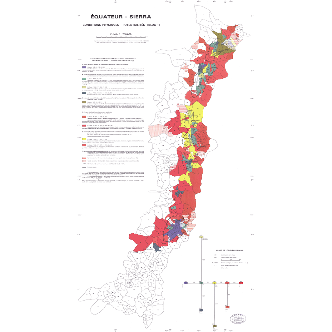
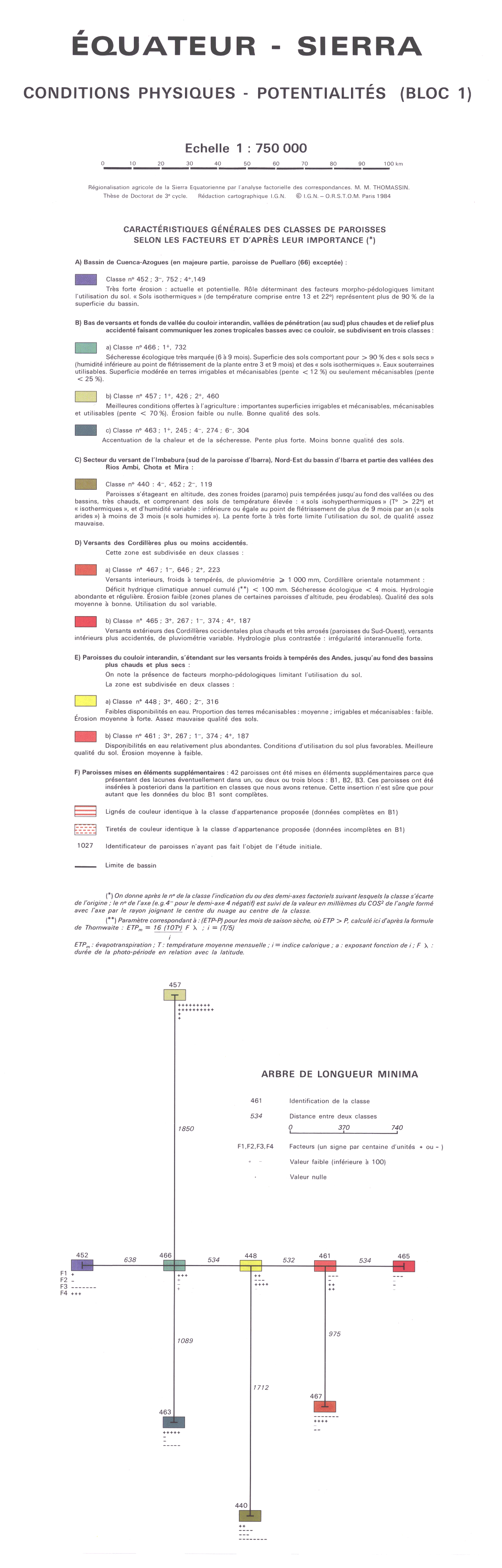
2. Equateur - Sierra : conditions physiques - potentialités (bloc 1). / Thomassin, Marie-Madeleine; Scale of 1:750 000. Date of publication: 1984. (file: 01363RC_IRD_ECU_EVPH_1984_750000_IRD_ECU_CSRE_1984-86_1000000-750000.tif)
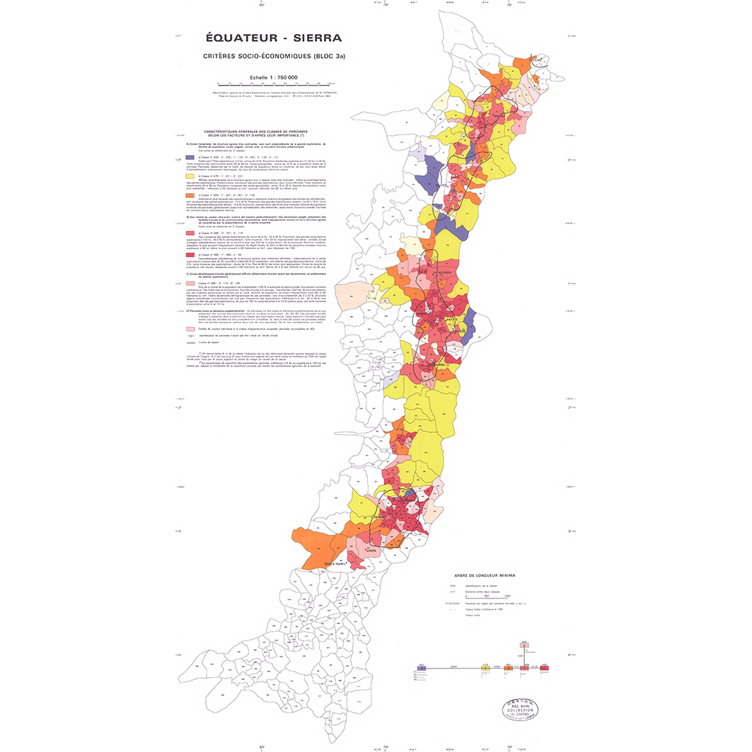
3. Equateur - Sierra : critères socio-économiques (bloc 3a). / Thomassin, Marie Madeleine; Scale of 1:750 000. Date of publication: 1984. (file: 01366RC_IRD_ECU_POSE_1984_750000_IRD_ECU_CSRE_1984-86_1000000-750000.tif)
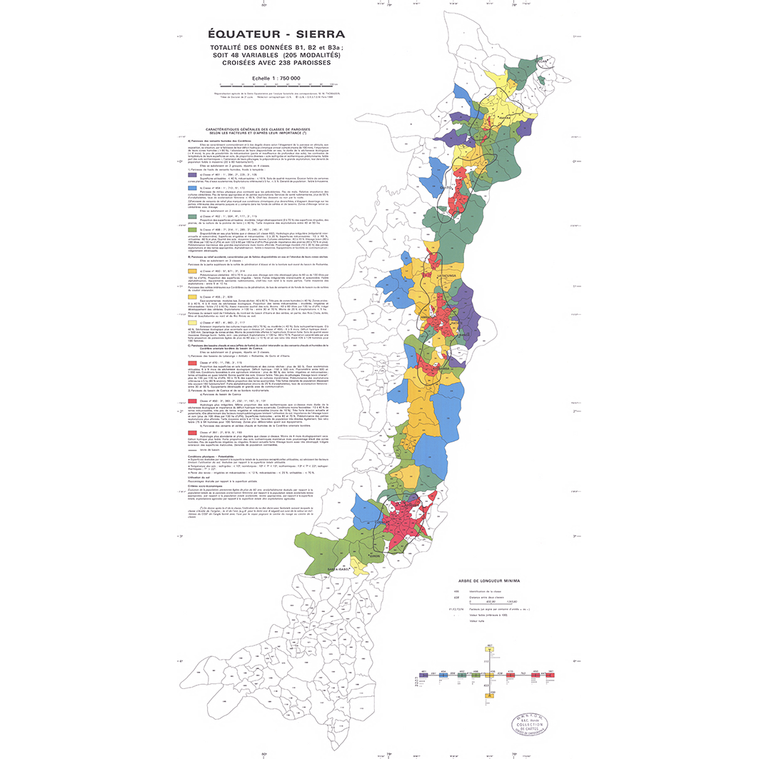
4. Equateur - Sierra : totalité des données B1, B2, et B3a ; soit 48 variables (205 modalités) croisées avec 238 paroisses. / Thomassin, Marie Madeleine; Scale of 1:750 000. Date of publication: 1984. (file: 01367RC_IRD_ECU_POSE_1984_750000_IRD_ECU_CSRE_1984-86_1000000-750000.tif)
Simple
- Date (Publication)
- 1984-01-01
- Citation identifier
- IRD_ECU_CSRE_1984-86_1000000-750000
- Credit
-
The region Île-de-France, under the project NumeriSud, supported the action to transforme around 2800 maps that are conserved at the Institut de recherche pour le développement (IRD) library in Bondy into a standard coordinate system. The transformation of the images has been done by Global Mapping Resources (South Africa) under the supervision of R. Zaiss (éditeur) 2014.
- Status
- Completed
- Point of contact
-
Organisation name Individual name Electronic mail address Role Institut de recherche pour le développement (IRD)
Production cartographique IRD
Point of contact Gondard, P.
Author Thomassin, Marie Madeleine
Author Thomassin, Marie-Madeleine
Author Valton, C. (ill.)
Author IGN, Institut géographique national
editor ORSTOM, Institut français de recherche scientifique pour le développement en coopération
editor
- Maintenance and update frequency
- Not planned
-
Geounits
-
-
Americas
-
South America
-
Ecuador
-
- Theme
-
-
thematic map
-
- Keywords
-
-
project NumeriSud
-
map collection
-
local coverage
-
labex CEBA
-
- Use limitation
-
Licence : CC-BY-NC-SA
- Access constraints
- licence
- Classification
- Unclassified
- Spatial representation type
- Grid
- Denominator
- 750000
- Language
- Français
- Character set
- UTF8
- Topic category
-
- Geoscientific information
- Planning cadastre
- Society
))
- Begin date
- 1984-01-01
- End date
- 1986-12-31
- Supplemental Information
-
Publication(s):
Gondard, P. (1986): La sierra équatorienne : régionalisation et analyse des données. Paris (FRA) : ORSTOM, Institut français de recherche scientifique pour le développement en coopération.
Thomassin, M. M. (1984): La sierra équatorienne : régionalisation et analyse des données. Paris (FRA) : ORSTOM, Institut français de recherche scientifique pour le développement en coopération ; Paris (FRA) : IGN, Institut géographique national.
- Reference system identifier
- EPSG / 4326 / 7.9
- Distribution format
-
Name Version GeoTIFF
1.0
- Distributor contact
-
Organisation name Individual name Electronic mail address Role DataSuds-geo
Publisher
- OnLine resource
-
Protocol Linkage Name OGC:WMS
https://datasuds-geo.ird.fr/geoserver/wms sphaera_ws:01365RC_IRD_ECU_USOL_1986_1000000_IRD_ECU_CSRE_1984-86_1000000-750000
WWW:DOWNLOAD:GeoTIFF https://datasuds-geo.ird.fr/geoserver/ows?service=WCS&version=2.0.1&request=GetCoverage&coverageId=01365RC_IRD_ECU_USOL_1986_1000000_IRD_ECU_CSRE_1984-86_1000000-750000 WWW:LINK-1.0-http--related
https://www.documentation.ird.fr/hor/fdi:25683 Notice explicative ou autre ouvrage
- OnLine resource
-
Protocol Linkage Name OGC:WMS
https://datasuds-geo.ird.fr/geoserver/wms sphaera_ws:01363RC_IRD_ECU_EVPH_1984_750000_IRD_ECU_CSRE_1984-86_1000000-750000
WWW:DOWNLOAD:GeoTIFF https://datasuds-geo.ird.fr/geoserver/ows?service=WCS&version=2.0.1&request=GetCoverage&coverageId=01363RC_IRD_ECU_EVPH_1984_750000_IRD_ECU_CSRE_1984-86_1000000-750000 WWW:LINK-1.0-http--related
https://www.documentation.ird.fr/hor/fdi:25683 Notice explicative ou autre ouvrage
- OnLine resource
-
Protocol Linkage Name OGC:WMS
https://datasuds-geo.ird.fr/geoserver/wms sphaera_ws:01366RC_IRD_ECU_POSE_1984_750000_IRD_ECU_CSRE_1984-86_1000000-750000
WWW:DOWNLOAD:GeoTIFF https://datasuds-geo.ird.fr/geoserver/ows?service=WCS&version=2.0.1&request=GetCoverage&coverageId=01366RC_IRD_ECU_POSE_1984_750000_IRD_ECU_CSRE_1984-86_1000000-750000 WWW:LINK-1.0-http--related
https://www.documentation.ird.fr/hor/fdi:25683 Notice explicative ou autre ouvrage
- OnLine resource
-
Protocol Linkage Name OGC:WMS
https://datasuds-geo.ird.fr/geoserver/wms sphaera_ws:01367RC_IRD_ECU_POSE_1984_750000_IRD_ECU_CSRE_1984-86_1000000-750000
WWW:DOWNLOAD:GeoTIFF https://datasuds-geo.ird.fr/geoserver/ows?service=WCS&version=2.0.1&request=GetCoverage&coverageId=01367RC_IRD_ECU_POSE_1984_750000_IRD_ECU_CSRE_1984-86_1000000-750000 WWW:LINK-1.0-http--related
https://www.documentation.ird.fr/hor/fdi:25683 Notice explicative ou autre ouvrage
- OnLine resource
-
Protocol Linkage Name DOI
https://doi.org/10.23708/f906b33c-120c-4ab5-b1f6-c6fe8bc8d33b Digital Object Identifier (DOI)
- Hierarchy level
- Dataset
- Statement
-
1. Scanning to tif format, 256 colors, 250dpi.
2. Georeferencing and if possible reprojection to WGS84 (Longitude / Latitude).
3. Clipping and mosaicing of map sheets(s).
4. Export ECW format.
5. ECW to GeoTIFF format conversion.
Metadata
- File identifier
- f906b33c-120c-4ab5-b1f6-c6fe8bc8d33b XML
- Metadata language
- English
- Character set
- UTF8
- Hierarchy level
- Dataset
- Hierarchy level name
-
dataset
- Date stamp
- 2024-02-13T18:39:50.193272Z
- Metadata standard name
-
ISO 19115:2003/19139
- Metadata standard version
-
1.0
- Metadata author
-
Organisation name Individual name Electronic mail address Role Institut de recherche pour le développement (IRD)
Service de l'Information Scientifique et Technique (IST) IRD
Point of contact Institut de recherche pour le développement (IRD)
IRD
Resource provider
Overviews
Spatial extent
Provided by
