 DataSuds-geo
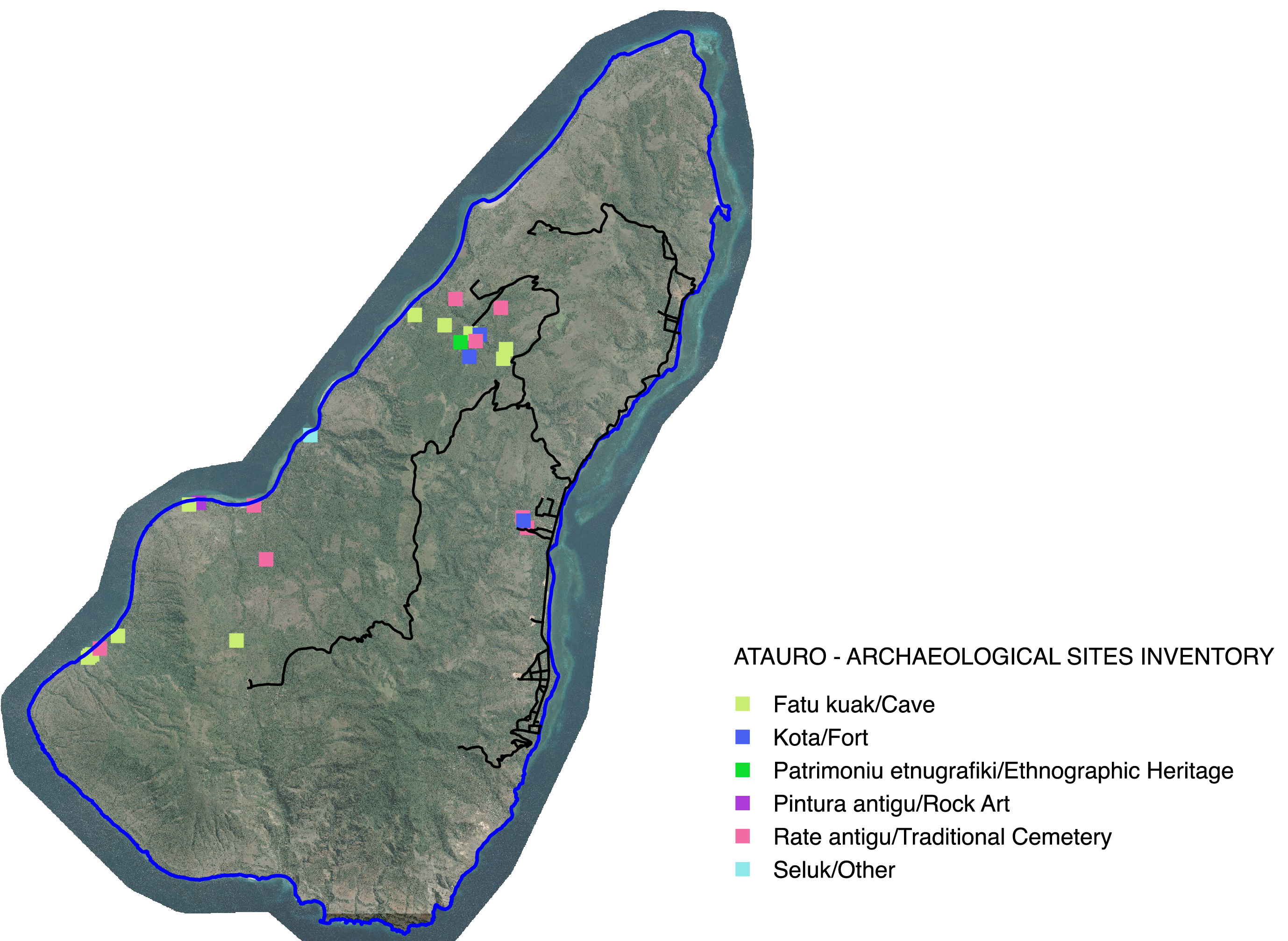
Archaeological sites- Atauro Island - East Timor - Asia
Identification and digitization of archaeological sites on Atauro Island, East Timor. The data collected comes from fieldwork carried out on the island of Atauro between 2013 and 2020 by Jean-Christophe Galipaud as part of missions funded by the IRD and then by the ANR 18-CE27-020 program.
Simple
- Date (Publication)
- 2024-07-24
- Edition
-
IRD
Citation identifier
- Presentation form
- Digital map
- Purpose
-
The challenge of this heritage data is to meet the expectations of local people while preserving the confidential nature or restricted circulation of certain knowledge or stories. Maps, drawn up on request, are the preferred medium for local dissemination insofar as the entire operational chain, from the GPS point to the associated information and its graphic processing, is visible and accessible to the SEAC technicians trained by the project and to part of the local population.
- Status
- Completed
- Point of contact
-
Organisation name Individual name Electronic mail address Role Institut de recherche pour le développement
Dominique Guillaud
Resource provider IRD-UMR PALOC
Elisabeth Habert
Author IRD - UMR PALOC
Elisabeth Habert
Point of contact
- Maintenance and update frequency
- Not planned
- Metadata author
-
Organisation name Individual name Electronic mail address Role IRD - UMR Paloc
Dominique Guillaud
Resource provider IRD
Elisabeth Habert
Point of contact
- Theme
-
-
Heritage, archaeology
-
- Place
-
-
Timor oriental, Atauro
-
- Access constraints
- Intellectual property rights
- Use constraints
- Copyright
- Other constraints
-
Free use subject to mentioning the source and citing the origin of the data when used for publication: Programme ANR 18-CE27-020 - UMR PALOC - J-C. Galipaud, E. Habert -
- Spatial representation type
- Vector
- Denominator
- 100000
- Language
- Français
- Character set
- UTF8
- Topic category
-
- Society
- Begin date
- 2013-05-19
- End date
- 2020-10-28
))
- Reference system identifier
- WGS 1984 - EPSG 4326
- Geometric object type
- Point
- Geometric object count
- 26
- Distribution format
-
Name Version Vecteur ou Shapefile,etc
Distributor
- Distributor contact
-
Organisation name Individual name Electronic mail address Role IRD
Publisher
- Distributor format
-
Name Version Vecteur ou Shapefile
- OnLine resource
-
Protocol Linkage Name OGC:WMS https://datasuds-geo.ird.fr/geoserver/paloc_ws/wms SItes_Archeologiques_Atauro
OGC:WFS https://datasuds-geo.ird.fr/geoserver/paloc_ws/wfs paloc_ws:SItes_Archeologiques_Atauro
DOI https://doi.org/10.1080/03122417.2021.1889085 Timorese archaeobotany: An anthracological pilot study at the late Holocene Lepu-Kina rockshelter, Atauro Island, East Timor
DOI https://doi.org/10.4000/12xv1 Conflict, Defensive Sites and Oral Tradition: A History of Settlement in Atauro
- OnLine resource
-
Protocol Linkage Name DOI
https://doi.org/10.23708/015195a0-ae5b-455e-9ca4-4cab44274fcd Digital Object Identifier (DOI)
- Hierarchy level
- Dataset
- Statement
-
GPS data collected during field missions on Atauro Island (East Timor) between 2013 and 2020 by Jean-Christophe Galipaud, UMR PALOC - IRD/MNHN
Metadata
- File identifier
- 015195a0-ae5b-455e-9ca4-4cab44274fcd XML
- Metadata language
- Français
- Character set
- UTF8
- Hierarchy level
- Dataset
- Date stamp
- 2025-03-14T10:10:13.191471Z
- Metadata standard name
-
ISO 19115:2003/19139
- Metadata standard version
-
1.0
- Metadata author
-
Organisation name Individual name Electronic mail address Role IRD - UMR PALOC
Elisabeth Habert
Author IRD - UMR Paloc
Dominique Guillaud
Publisher
- Other language
-
Language Character encoding English UTF8 French UTF8
Overviews
Spatial extent
Provided by
