 DataSuds-geo
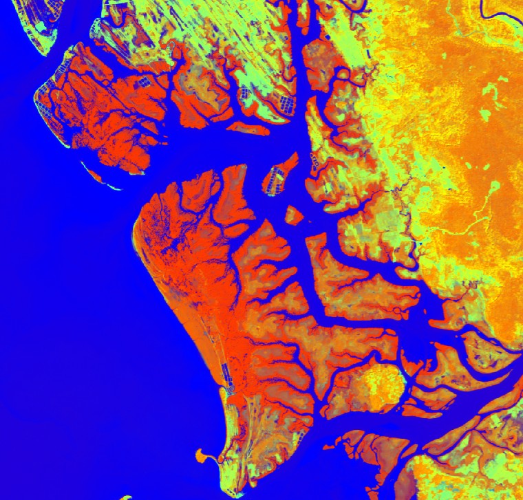
Mangrove distrbution in Cambodia in 2020
This map of mangrove distribution in Cambodia in 2020 was produced using Sentinel 2 images dated january 2020 obtained from the Copernicus Browser ( https://browser.dataspace.copernicus.eu/). The images cover 4 Sentinel 2 tiles (T48PTT, T48PUS, T48PUT, T48PVS), located on the coast of Cambodia and covering the mangrove ecosystems of Cambodia. A total of 4 raster products is available, one binary product for each tile, with values of 1 coresponding to mangrove and values of 0 corresponding to non-mangrove. The maps of mangrove were obtained following a methodology developed in the fram eof the Mangmap project ( https://mangmap.org/en/) and availbale here ( https://mangmap.org/en/produit/le-vecteur-de-contour-des-mangroves/). For each Sentinel 2 tile, a multi-band raster was produced combining NDVI, NDWI, SWIR and the Copdem DEM at 30 m resolution. A thresholding approach was performed on this multi-band raster to detect mangrove pixels and to produce a final map at 30 m resolution for each tile.
Simple
- Date (Creation)
- 2026-02-16
- Date (Publication)
- 2026-03-17
Citation identifier
- Presentation form
- Digital map
- Purpose
-
This map of the distribution of mangrove in Cambodia in 2020 was produced to be used as a reference for research actions that will be developed in the frame of the ANIMALS project and operational monitoring actions to be developed in the frame of the MangMap project. In both these projects, satellite imagery at different spatial resolutions (Sentinel 2 and Pleiades), will be used to produce:
- up to date knowlegde on mangrove habitats, above-ground biomass (AGB) and above-ground carbon (AGC) stocks using very high spatial resolution provided by Pleiades (50 cm).
- monitor the evolution of mangrove distribution using sentinel 2 time series (10 m resolution) from 2020, and contirbute to the development of an alert system dedicated to early detections of changes in mangrove in Cambodia.
These data is intended to be fully available for on going projects, including the involved partners and any actors with interest in mangrove conservation in Cambodia.
- Credit
-
ANIMALS project, funded by TOSCA CNES, grant agreements 5800003778 and 5800003771
Mangmap project, funded by SCO CNES
- Status
- Completed
- Point of contact
-
Organisation name Individual name Electronic mail address Role UMR ESPACE-DEV - IRD, Univ.Montpellier, Univ.La Réunion, Univ.Guyane, Univ.Antilles, Univ. Nouvelle Calédonie, Univ. Perpignan Via Domitia - France
Catry, Thibault
Author IRD - France
MSO
Distributor UMR ESPACE-DEV - IRD, Univ.Montpellier, Univ.La Réunion, Univ.Guyane, Univ.Antilles, Univ. Nouvelle Calédonie, Univ. Perpignan Via Domitia - France
Faure, jean-François
Author UMR ESPACE-DEV - IRD, Univ.Montpellier, Univ.La Réunion, Univ.Guyane, Univ.Antilles, Univ. Nouvelle Calédonie, Univ. Perpignan Via Domitia - France
Blanchard, Elodie
Author UAR Data Terra - CNRS, CNES, IFREMER, IGN, INRAE, IRD, Meteo France - France
Esparon, Amanda
User UMR ESPACE-DEV - IRD, Univ.Montpellier, Univ.La Réunion, Univ.Guyane, Univ.Antilles, Univ. Nouvelle Calédonie, Univ. Perpignan Via Domitia - France
Catry, Thibault
Point of contact
- Maintenance and update frequency
- Annually
- Metadata author
-
Organisation name Individual name Electronic mail address Role UMR ESPACE-DEV - IRD, Univ.Montpellier, Univ.La Réunion, Univ.Guyane, Univ.Antilles, Univ. Nouvelle Calédonie, Univ. Perpignan Via Domitia - France
Catry, Thibault
Point of contact
-
Geounits
-
-
Cambodia
-
- Theme
-
-
thematic map
-
- Use limitation
-
This work is made available under the terms of the Creative Commons Attribution 4.0 International Licence ( https://creativecommons.org/licenses/by/4.0/deed.fr).
Good scientific practice requires that the source of these data be cited when used, using the following format:
‘Catry, T., Faure, jean-F. and Blanchard, E. (2026) “Mangrove distrbution in Cambodia in 2020.” DataSuds-geo. doi: 10.23708/4B2F6D81-5BE9-43F0-AA5B-F92089095397’
- Access constraints
- License
- Use constraints
- License
- Spatial representation type
- Grid
- Denominator
- 30
- Language
- Français
- Character set
- UTF8
- Begin date
- 2020-01-01
- End date
- 2020-01-31
))
- Supplemental Information
-
This dataset is part of the "UMR Espace-Dev" collection in the DataSuds-geo IRD repository.
- Reference system identifier
- WGS 1984 - EPSG 4326
- Geometric object type
- Surface
- Distribution format
-
Name Version Geotiff
- Distributor contact
-
Organisation name Individual name Electronic mail address Role DataSuds-geo
Distributor
- OnLine resource
- OnLine resource
-
Protocol Linkage Name DOI
https://doi.org/10.23708/4b2f6d81-5be9-43f0-aa5b-f92089095397 Digital Object Identifier (DOI)
- Hierarchy level
- Dataset
Metadata
- File identifier
- 4b2f6d81-5be9-43f0-aa5b-f92089095397 XML
- Metadata language
- Français
- Character set
- UTF8
- Hierarchy level
- Dataset
- Date stamp
- 2026-04-20T07:46:37.413487Z
- Metadata standard name
-
ISO 19115:2003/19139
- Metadata standard version
-
1.0
- Metadata author
-
Organisation name Individual name Electronic mail address Role UMR ESPACE-DEV - IRD, Univ.Montpellier, Univ.La Réunion, Univ.Guyane, Univ.Antilles, Univ. Nouvelle Calédonie, Univ. Perpignan Via Domitia - France
Nom, Prénom
Author
- Other language
-
Language Character encoding English UTF8 French UTF8
Overviews
Spatial extent
Provided by
