 DataSuds-geo
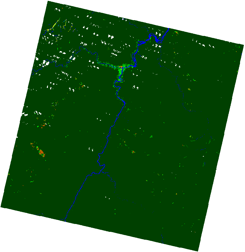
Occupation/usage du sol, Camopi, 2009
Classification d'occupation/usage du sol obtenue à partir de la scène SPOT5 acquise le 17/10/2009
Simple
- Date (Publication)
- 2024-01-22
- Citation identifier
- Classification_Groupe_Paludisme_Camopi_2009
- Point of contact
-
Organisation name Individual name Electronic mail address Role UMR ESPACE-DEV - IRD, Univ.Montpellier, Univ.La Réunion, Univ.Guyane, Univ.Antilles
Dessay, Nadine
Author UMR ESPACE-DEV - IRD, Univ.Montpellier, Univ.La Réunion, Univ.Guyane, Univ.Antilles
Dessay, Nadine
Point of contact Li, Zhichao
Author UMR ESPACE-DEV - IRD, Univ.Montpellier, Univ.La Réunion, Univ.Guyane, Univ.Antilles
Roux, Emmanuel
Author
- Maintenance and update frequency
- As needed
-
GEMET - INSPIRE themes, version 1.0
-
-
Land cover
-
- Keywords
-
-
Paludisme
-
- category
-
-
Données thématiques
-
- acquisition
-
-
Autre
-
- themes
-
-
Risque de transmission de la malaria
-
- subtheme
-
-
Occupation des sols, Paysages et Risques
-
- Use limitation
-
Licence : CC-BY
- Access constraints
- License
- Classification
- Unclassified
- Spatial representation type
- Grid
- Distance
- 10 http://schemas.opengis.net/iso/19139/20070417/resources/uom/gmxUom.xml#xpointer(//*[@gml:id='m'])
- Language
- Français
- Topic category
-
- Health
))
- Reference system identifier
- WGS84 - EPSG:4326
- Distribution format
-
Name Version GeoTIFF
- Distributor contact
-
Organisation name Individual name Electronic mail address Role DataSuds-geo
Publisher
- Transfer size
- 1.464
- OnLine resource
-
Protocol Linkage Name OGC:WMS https://datasuds-geo.ird.fr/geoserver/espace_dev_ws/wms Guyamapa_classif
FILE:RASTER https://datasuds-geo.ird.fr/geoserver/ows?service=WCS&version=2.0.1&request=GetCoverage&coverageId=Guyamapa_classif Occupation/usage du sol - Camopi - 2009.
WWW:DOWNLOAD-1.0-http--download https://datasuds-geo.ird.fr/geonetwork/umr_espace_dev/api/records/fe7fc64d-802a-4e23-8f88-bb3326099e2e/attachments/Guyamapa_classif.qml Guyamapa_classif.qml
WWW:DOWNLOAD-1.0-http--download https://datasuds-geo.ird.fr/geonetwork/umr_espace_dev/api/records/fe7fc64d-802a-4e23-8f88-bb3326099e2e/attachments/Guyamapa_classif.csv Guyamapa_classif.csv
- OnLine resource
-
Protocol Linkage Name DOI
https://doi.org/10.23708/fe7fc64d-802a-4e23-8f88-bb3326099e2e Digital Object Identifier (DOI)
- Hierarchy level
- Dataset
Conformance result
- Date (Publication)
- 2010-05-03
- Explanation
-
Non évalué
- Statement
-
Réalisée par Zhichao Li, Nadine Dessay et Emmanuel Roux en fusionnant et relabellisant des classes de la carte d'occupation/usage du sol du Projet Ose-Guyamapa.
UMR Espace-Dev
- Included with dataset
- No
- Cited responsible party
-
Organisation name Individual name Electronic mail address Role
Metadata
- File identifier
- fe7fc64d-802a-4e23-8f88-bb3326099e2e XML
- Metadata language
- Français
- Hierarchy level
- Dataset
- Date stamp
- 2024-01-22T09:40:28.928284Z
- Metadata standard name
-
ISO19115
- Metadata standard version
-
2011.03
- Metadata author
-
Organisation name Individual name Electronic mail address Role UMR ESPACE-DEV - IRD, Univ.Montpellier, Univ.La Réunion, Univ.Guyane, Univ.Antilles
Roux, Emmanuel
Point of contact
Overviews
Spatial extent
Provided by
